Friday Discussion : Weather roller coaster

Morning! Good old fashion weather roller coaster over the next 24 hours!
Synopsis for those on the go-
Unsettled today with rounds of showers and some heavier downpours possible, but the main concern comes late this afternoon and evening.
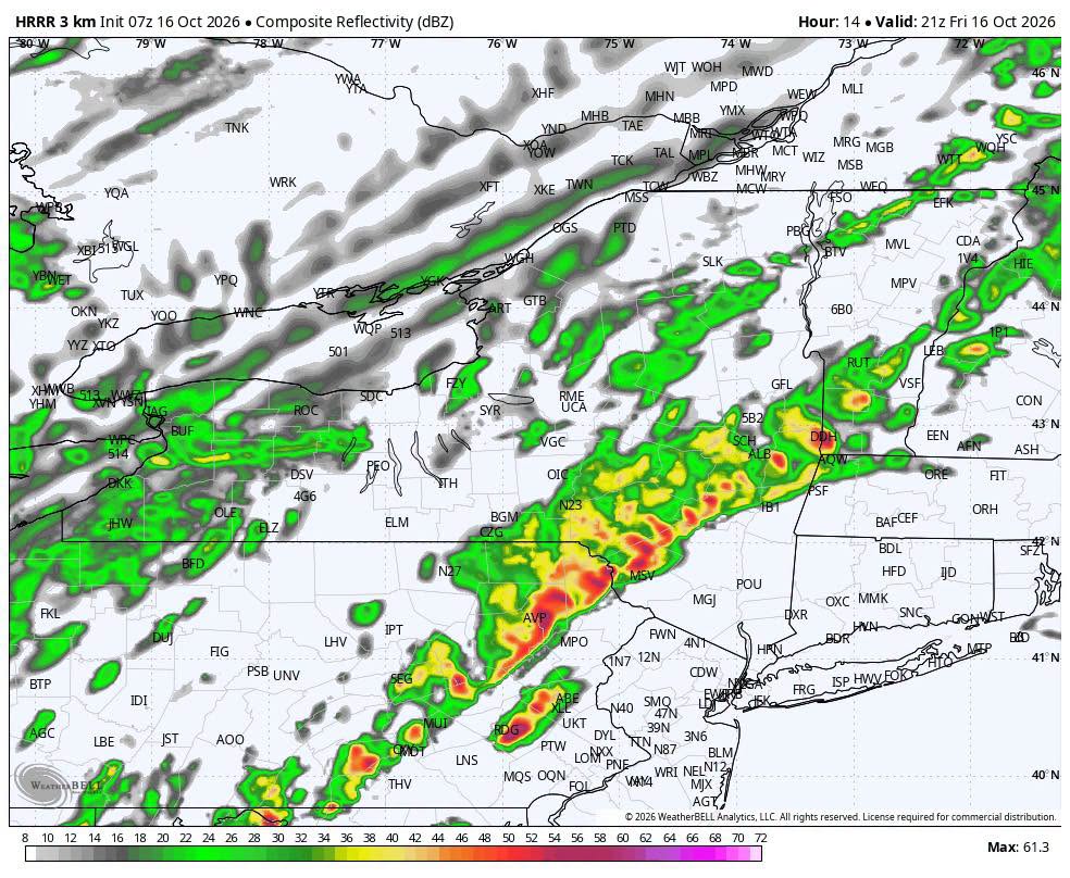
– A fast-moving line of showers/storms is expected to cross the region roughly 5–8 PM, with the potential for a quick burst of 40–50+ MPH wind gusts and isolated tree/power issues.
– Temperatures may still be near 70° in parts of the southern Hudson Valley this evening before crashing behind the front.
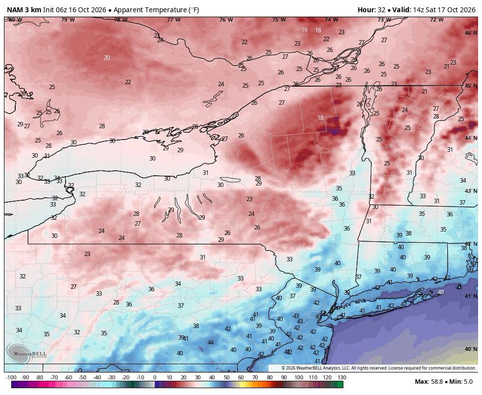
– Saturday turns sharply colder and blustery, with highs mainly in the 40s and feels-like temperatures in the 20s and 30s during the morning.
– A few flakes are even possible across the highest terrain late tonight into Saturday morning.
We’re also keeping an eye on next week for the possibility of a sneaky coastal system trying to develop along the offshore frontal boundary.
Nerd Alert below for the full breakdown.
BIG FRIDAY FLIP — SHOWERS TODAY, SQUALL LINE THIS EVENING, THEN A RUDE SATURDAY MORNING
We’ve got quite the weather transition ahead over the next 24 hours.
Today will be unsettled from the start, with periods of rain and scattered showers moving through the region well before the main cold front arrives. Some areas could even hear a rumble of thunder this morning, and a few heavier downpours are possible.
There will also be breaks between showers, and temperatures will respond quickly wherever we get some drying or filtered sunshine.
A surge of mild air ahead of the front will push temperatures well into the 60s, with portions of the southern Hudson Valley still sitting in the upper 60s to near 70° late this afternoon and early this evening.
Then comes the main event.
5–8 PM — WATCHING A FAST-MOVING SQUALL LINE
A narrow line of showers and thunderstorms is expected to develop along the approaching cold front and sweep west to east through the region late this afternoon and evening.
The atmosphere won’t be especially unstable, but there is a tremendous amount of wind just above the surface, with 50–60 knot wind shear available to a low-topped line of storms.
That means stronger showers or thunderstorms may be capable of briefly transferring some of that momentum downward.
The primary concern is a quick burst of damaging wind.
A reasonable timing progression:
– Delaware / Sullivan / western Catskills: late afternoon into early evening
– Ulster / Greene / Orange / Mid-Hudson Valley: roughly 5–7 PM
– Dutchess / Columbia / Putnam / Rockland / Westchester: roughly 6–8 PM
The line itself may only last 15–30 minutes at any one location.
During that window:
– Sudden gusts potentially 40–50+ MPH
– Brief heavy rain
– A few thunderstorms
– Isolated downed limbs or power outages
Even where thunderstorms don’t fully develop, the frontal passage itself could produce a quick burst of 35–45 MPH wind gusts.
So don’t judge this front by how much lightning you see.
This is much more of a wind-driven frontal passage than a classic warm-season thunderstorm event.
THEN THE TEMPERATURE FALLS OFF A CLIFF
Some southern locations could still be near 70° early this evening.
By Saturday morning, many locations will be in the 30s, with 40s mainly confined to the lower elevations and far southern portions of the region.
Higher elevations could fall toward or below freezing.
Add northwest winds gusting 25–35 MPH, and it will feel substantially colder.
Saturday morning apparent temperatures could fall into:
– 20s across the Catskills and higher terrain
– Upper 20s to 30s across much of the Hudson Valley
– Around 40° or lower even across portions of our southern counties
SATURDAY — COLD, BLUSTERY & RAW
Saturday will likely be one of the coldest-feeling Saturdays we’ve had since early spring.
Actual afternoon temperatures struggle through the 40s in the valleys, with only 30s to lower 40s across the higher terrain.
Northwest winds continue gusting 25–35 MPH, keeping apparent temperatures in the 30s for much of the day and potentially only the 20s across the mountains.
– A few snow showers or flurries are possible across the highest terrain late tonight into Saturday morning.
Sunday is a slight warm up with low 50’s and calm winds.
BOTTOM LINE
– Periods of rain and showers possible throughout today
– Main frontal passage roughly 5–8 PM
– Brief damaging wind gusts possible with the line
– Temperatures plunge tonight
– Saturday morning feels-like values in the 20s and 30s
– Blustery and cold Saturday, highs mainly in the 40s
– A few high-elevation snow showers or flurries possible
It’s an unsettled day overall — with the late-day frontal passage being the period most likely to pack a punch.
LOOKING AHEAD
We’re also keeping an eye on next week for the potential of another sneaky coastal system trying to develop along the stalled frontal boundary offshore.
It’s very early and confidence is low, but those offshore boundaries can occasionally become the focus for secondary low pressure development.
Nothing to sound alarms over at this stage — just something we’ll be watching as the pattern evolves.
-Alex
Weekend Outlook: Nice Start, But Isaias Remnants Arrive Sunday PM

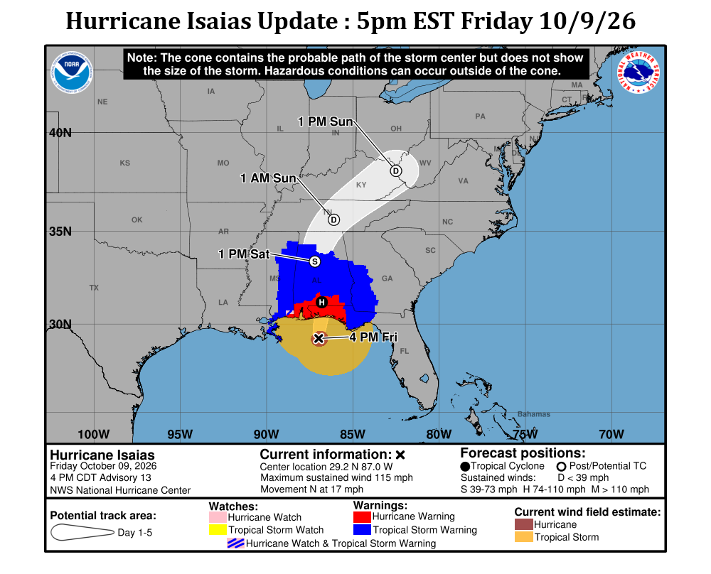
Hurricane Isaias is taking aim on the Gulf coast this evening, expecting to make landfall around Pensacola FL before midnight as a strong category 2 or weak category 3 hurricane. This will bring some powerful winds (100mph to 115mph sustained… with gusts over 130mph) to the western panhandle of Florida, so hopefully those folks are prepared and remain safe.
 
For us locally in the Hudson Valley, we’ll be protected by high pressure for the next 24 to 36 hours, and that will mean a nice start to our weekend. Saturday should see partly to mostly cloudy skies, with seasonable temperatures… highs in the mid 60s.
 
Saturday night we’ll see high clouds increasing as Hurricane Isaias gets sheared apart over the eastern US after making landfall. This will spread clouds and rain showers northward, into the Ohio valley Saturday night. In the Hudson Valley, we’ll see increasing clouds and overnight lows in the 40s.
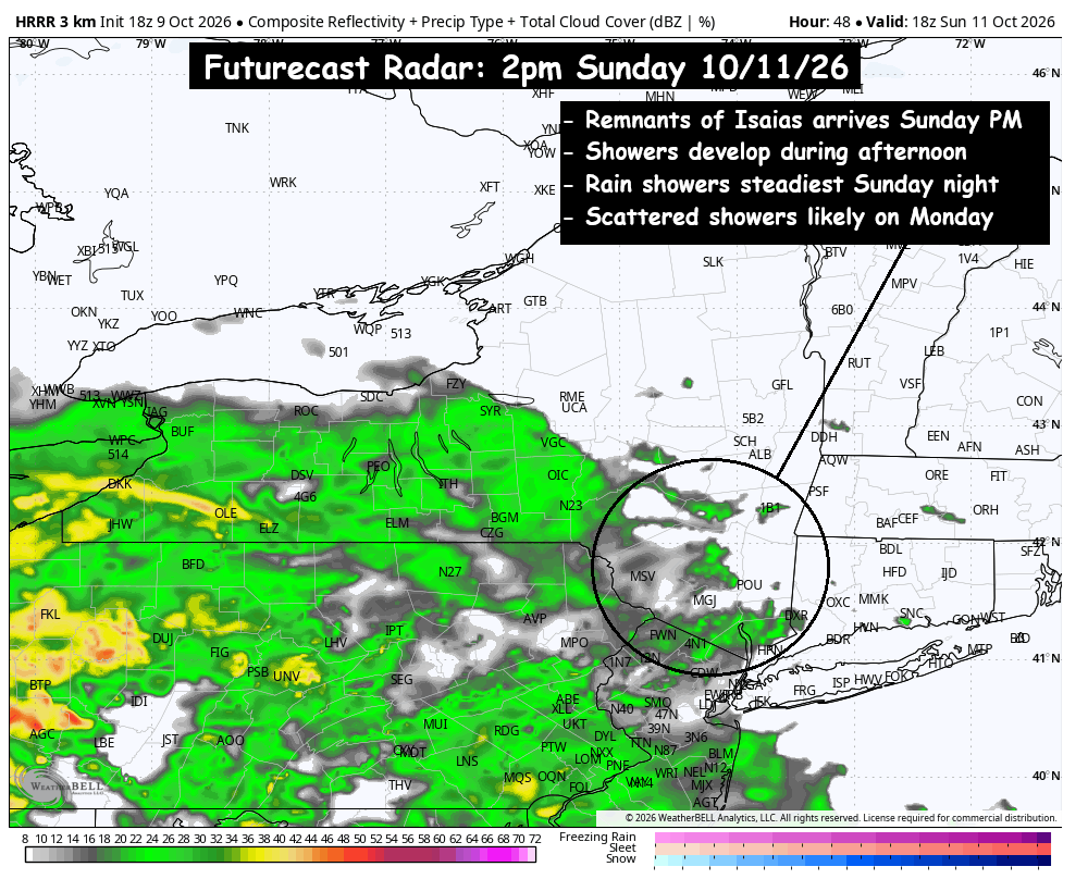
Sunday morning, the rainfall from the remnants of Isaias will move into the Ohio Valley and head into the Mid Atlantic states… gradually heading toward the Hudson Valley. The morning hours look mainly dry in the Hudson Valley, with the bulk of the moisture still being to our southwest in the Ohio Valley and western PA. However, as Isaias continues to weaken and the remnants move further inland on Sunday… the moisture associated with the system will be spread far out ahead of the Tropical Depression itself. Scattered rain showers and areas of steady rain will likely reach the Hudson Valley during the early to mid-afternoon hours on Sunday. So expect periods of rain showers to impact your afternoon and evening plans on Sunday.
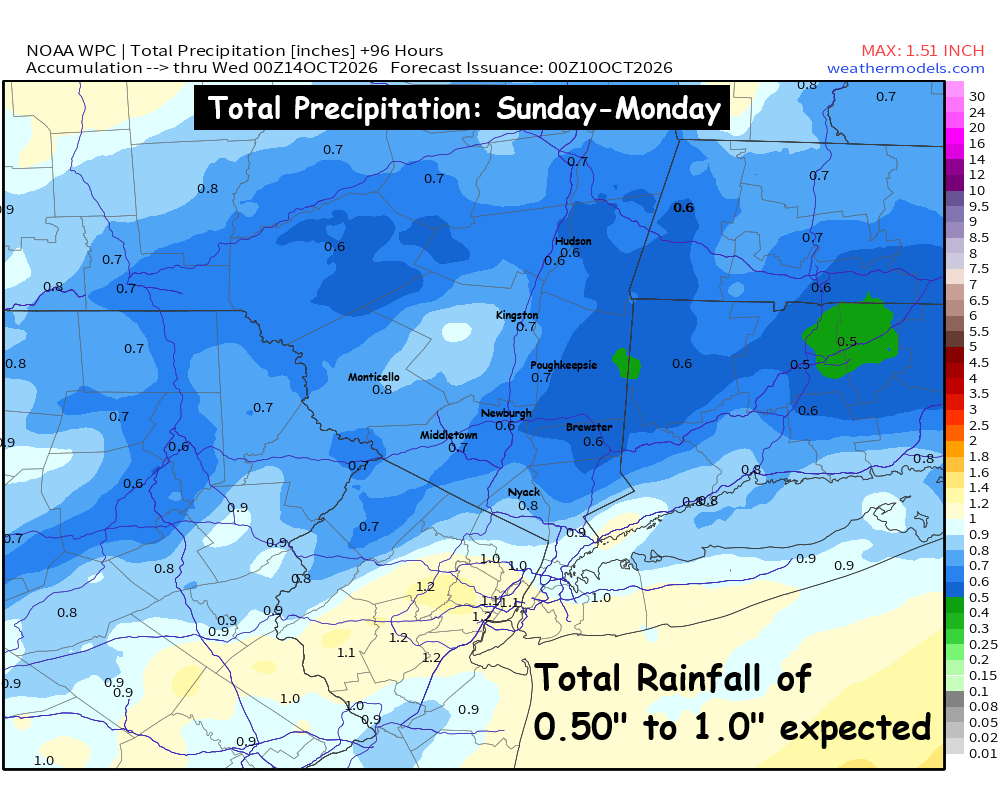
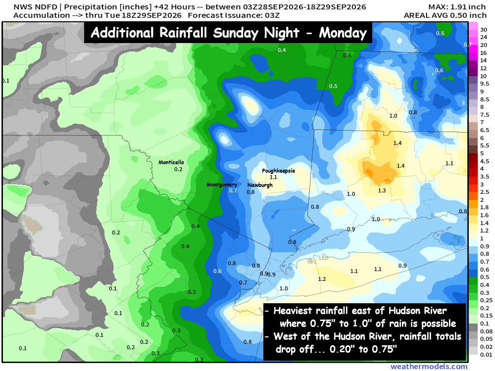
The heaviest rain showers are expected Sunday night, with scattered showers being likely to persist into the daytime hours on Monday. Rainfall totals do not appear to be too extreme… with most of the region seeing between 0.50″ and 1.0″ of rain. However these systems can have a few surprises… so we’ll keep our eyes on these details and update you accordingly. We hope your weekend gets off to a great start!
-Bill

Monday Discussion – Cooler, Feels like Fall

We started with a warm end to the work week, with highs in the mid 80s across portions of the region. But Saturday quickly returned to seasonable temperatures, and gave us a rather nice weekend… aside from a extra clouds on Sunday.
 
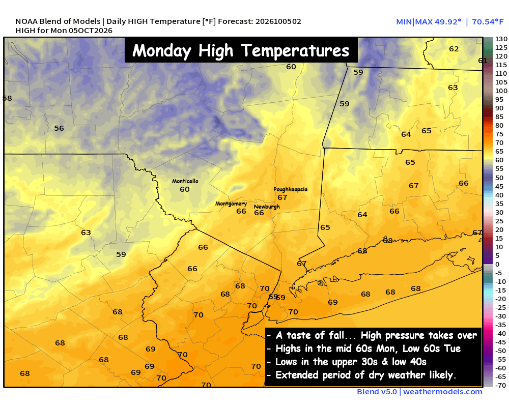
So as we look forward to the first full week of October, expect an extended stretch of high pressure. We’ll have a few troughs trying to dive in from Canada through the week, but at this time it looks like the high pressure will prevent much moisture from reaching the Hudson Valley this week.
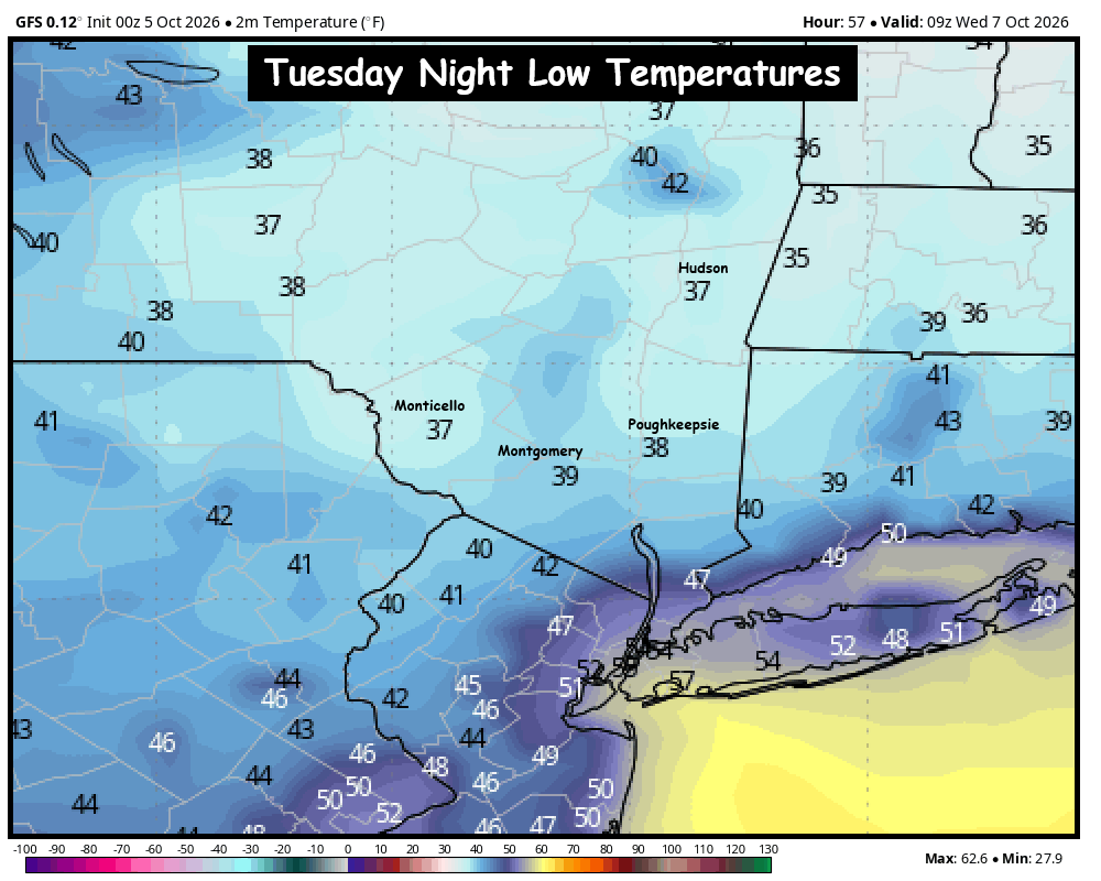
The big story will be the fall chill on both Monday and Tuesday nights. With cooler, Canadian air in place for the start of the week, the nights will get quite chilly. Clear skies and calm winds should allow overnight lows to fall near 40° in the Hudson Valley… with some colder spots dropping into the upper 30s. It doesn’t look like this air mass will be cold enough to get any areas of frost… but it’s something we’ll watch. Our guess is that we’ll have to wait for another cold front to get the first frost of the season in the Hudson Valley.
 
Monday: Clouds mixing with sun, a stray sprinkle. Breezy and seasonable. High in the mid to upper 60s.
Monday Night: Partly cloudy skies, turning clear overnight. Calm winds. Low in the low 40s. Patchy areas of upper 30s possible in colder spots.
Tuesday: Mostly sunny and cool. High in the low to mid 60s.
Tuesday Night: Mostly clear and very chilly. Low around 40°, with some upper 30s.
 
The next shot at rain looks likely to be next weekend possibly. So for now, enjoy the beautiful taste of fall weather.

Nor’easter Lingers and Weakens on Monday

– MONDAY:
Scattered rain showers diminishing later in the day. Cloudy and breezy, with diminishing wind. Chilly. High in the upper 50s.
– MONDAY NIGHT:
An early scattered shower, otherwise variable clouds, with winds turning calm. Low in the low 50s.
– TUESDAY:
Clouds mixing with sunshine, warmer. Highs around 70°.
 
– REST OF THE WEEK:
Dry… sunshine and clouds… warmer… with afternoon highs in the 70s.
 
After a VERY windy and VERY stormy weekend, our work week doesn’t start off that much better. The Nor’easter will slowly push NE on Monday as it completely falls apart. But that will mean low clouds and scattered showers through most of the day. The good news, is that the winds will be weakening and becoming much less of a factor on Monday. So that should really cut down on the number of power outages around the region… and allow our amazing Utility crews to catch up and get ahead of things. We’ll share updates about the impacts of the storm on Monday as needed. The Good news… is that behind this system, once the storm exits, we will see several days of tranquil weather thanks to a large area of high pressure pushing into the eastern US. Which will bring a MUCH welcome change to our weather after the past few days.

COASTAL STORM UPDATE — AFTER NEARLY 10 DAYS OF TRACKING OUR STORM HAS ARRIVED

COASTAL STORM UPDATE — AFTER NEARLY 10 DAYS OF TRACKING OUR STORM HAS ARRIVED-WAVES OF RAIN, WIND AND A LONG-DURATION WEEKEND EVENT
The nor’easter is now well established off the Mid-Atlantic coast and continues to strengthen while slowly lifting north.
For the Hudson Valley and Catskills, this remains a long-duration event rather than one continuous wall of rain. One of those first waves of heavier and steadier rain is pushing through the region at this early hour. What you’re seeing outside right now, won’t necessarily be the conditions all day, models continue to support lulls later this morning and into the afternoon, more below.
The biggest thing to understand over the next 48 hours is that conditions will come in waves.
SATURDAY LATE MORNING / AFTERNOON
There is a legitimate opportunity for rainfall to ease or become much more scattered for a time.
Some locations may even turn mainly dry between bands, particularly farther north and west.
This does NOT mean the storm is ending.
It’s simply a temporary break as the circulation reorganizes and the surface low begins its westward turn.
So if you have plans today, there may be windows where conditions are considerably more manageable than the radar or broader storm headlines would suggest.
SATURDAY NIGHT INTO SUNDAY MORNING
This is the period we are watching for the most widespread and organized rainfall across the Hudson Valley.
As the storm pivots west toward the New Jersey coast, deeper Atlantic moisture wraps farther inland.
A broader shield of steady light to moderate rain should expand west and northwest overnight.
Some heavier bands are possible, especially from the eastern Catskills and Mid-Hudson Valley eastward.
The period from roughly overnight through Sunday morning, and potentially into late Sunday morning or early afternoon, looks like the best opportunity for the steadiest rainfall across much of the region.
SUNDAY AFTERNOON
Once again, rainfall may become less organized.
Instead of a solid rain shield, we may transition back toward lighter rain, showers and breaks between bands.
That said, we are not forecasting a dry Sunday afternoon everywhere.
The storm will still be sitting nearby and rotating moisture around its circulation.
SUNDAY NIGHT INTO MONDAY
As the low continues to meander and loop near the New Jersey coast, additional bands of rain may rotate back across the region Sunday evening and Sunday night.
Showers could linger into Monday before the storm finally begins getting pulled northeast and away from us Monday night into Tuesday.
So the overall theme is:
Saturday morning — periods of rain/showers
Saturday afternoon — possible lull / lighter and more scattered
Saturday night — rain becomes more widespread again
Sunday morning — steadiest and potentially heaviest inland rainfall
Sunday afternoon — more scattered/lighter again
Sunday night — additional wraparound rain possible
Monday — lingering showers gradually ending
RAIN TOTALS
There will still be a pronounced southeast-to-northwest gradient.
Highest totals are favored across:
• Westchester
• Rockland
• Putnam
• Dutchess
• eastern/southern Ulster
• eastern Catskills
• Columbia County
Amounts generally decrease farther west into:
• Sullivan
• Delaware
• western Ulster
• western Greene
For much of the Mid-Hudson Valley and eastern Catskills, storm totals of roughly 1–2.5 inches remain reasonable, with localized 3-inch totals possible where persistent bands develop.
Westchester and Rockland could also finish near or above 2 inches depending on where the heavier bands pivot.
Farther west into Delaware and Sullivan Counties, totals should be lower unless the storm’s precipitation shield pushes farther west than expected.
This rain is falling over a long period, so widespread flash flooding remains unlikely.
Poor drainage flooding, ponding and localized nuisance flooding are more likely concerns.
Minor tidal flooding is also expected along portions of the Hudson River, including around Poughkeepsie.
WIND
The wind forecast has become a little more interesting.
The strongest winds remain aloft, but daytime mixing today may be somewhat more efficient than earlier guidance suggested.
That could allow more widespread gusts of 30–40 MPH across:
• Mid-Hudson Valley
• eastern Catskills
• Columbia County
• Taconics
• exposed higher terrain
Farther south and east, including Westchester and Rockland, gusts may locally exceed 40 MPH.
The strongest winds still remain favored closer to the coast.
The important limiting factor remains the inversion.
Tonight, even though winds around 45–55 knots exist several thousand feet above us, a sharp stable layer should prevent the strongest winds from consistently reaching the surface.
So widespread 50–60 MPH gusts are still not expected inland.
But long-duration 30–40+ MPH gusts, fully foliated trees and increasingly wet soil can still produce scattered downed limbs and isolated power outages.
COUNTY-BY-COUNTY GENERAL IMPACT
Westchester / Rockland
Wettest and windiest portion of our coverage area overall. Periods of rain today, more organized rain tonight into Sunday morning, gusts frequently 30–40+ MPH with localized higher gusts possible.
Putnam / Dutchess
Periods of rain today with possible breaks this afternoon. Steadier rain develops tonight into Sunday morning. Gusts generally 30–40 MPH.
Orange / Ulster
More opportunity for dry breaks today. Rain becomes more widespread tonight into Sunday morning. Winds generally 25–40 MPH, strongest east.
Sullivan / Delaware
Farther removed from the strongest wind and heaviest rainfall. Showers possible today, with a better chance for steadier rain tonight into Sunday, but overall totals should be lower.
Greene / Columbia
Greene County will likely see a sharper rainfall gradient, especially west to east. Columbia County should see a better opportunity for steadier rain tonight into Sunday. Gusts generally 25–40 MPH, strongest in exposed areas.
BOTTOM LINE
This is not a “rains nonstop from Saturday through Monday” storm.
It is a slow-moving circulation that will repeatedly rotate bands of rain through the region.
There will be breaks.
There will be periods where radar looks much quieter.
Then another band rotates in.
The most important window for widespread rainfall across the Hudson Valley currently looks to be Saturday night into Sunday morning.
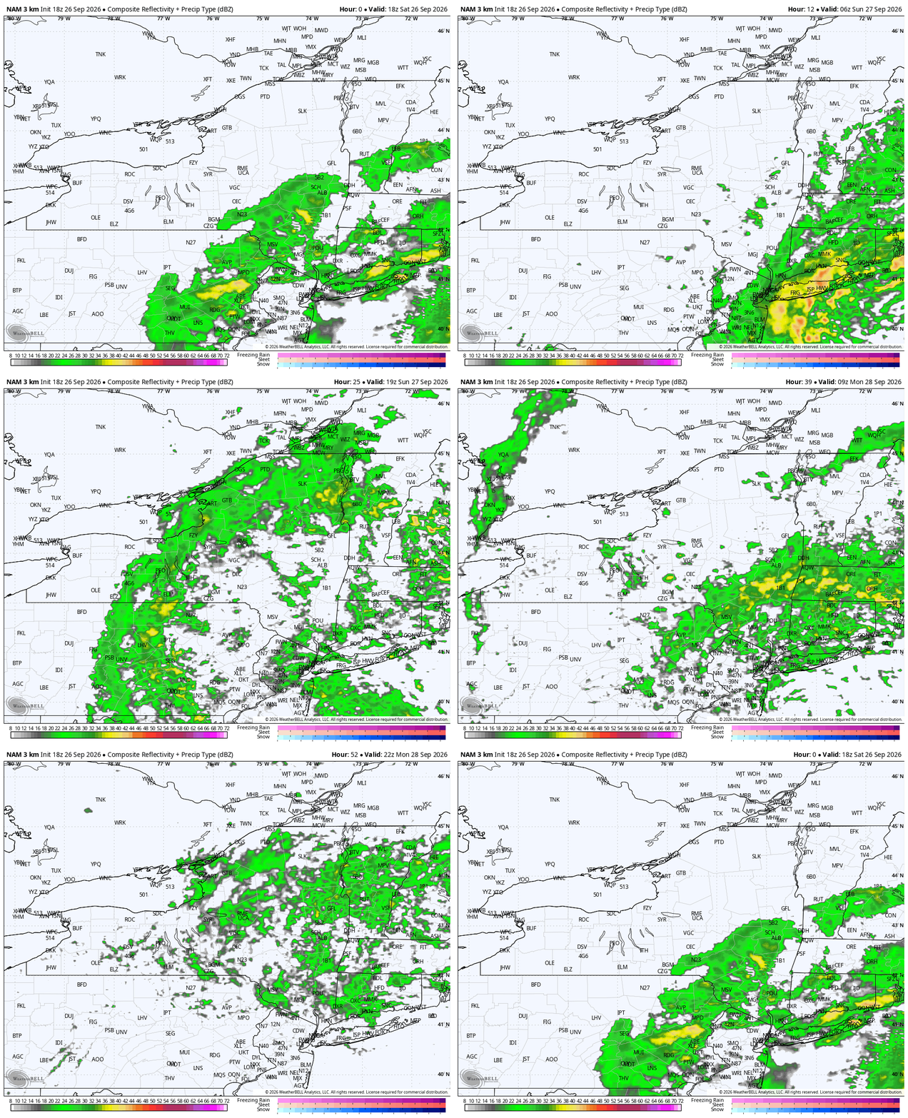
And because the storm refuses to leave, additional rounds remain possible through Sunday night and Monday. Attached is the NAM Model- simulated radar now through 2PM Monday.. again, long duration.
Hey all.. it’s been a minute, but don’t forget to Stay Calm and Weather On!
Talk more soon! Stay safe out there, I may even head to that Garlic Festival and try to support those vendors who are braving today’s weather!

COASTAL STORM UPDATE — NOW DEEPENING AND SLOWLY APPROACHING THE REGION

The nor’easter we’ve been tracking is now developing offshore, with surface pressure around 996mb this afternoon and additional strengthening expected tonight as it moves north.
The overall forecast has become clearer, but there are still important timing differences across the Hudson Valley.
The biggest change for us is that the storm has trended a little slower and a little farther south/west. That delays the meaningful rain farther inland and keeps the sharp western edge of the rain shield directly across our region.
FRIDAY EVENING / TONIGHT
Expect increasing clouds and a steadily strengthening north/northeast wind.
Most of the Hudson Valley remains relatively quiet early this evening, while rain continues expanding northwest from the NYC/Long Island area.
Wind gusts of 20–30 MPH will become increasingly common, especially south and east.
SATURDAY
This is still the toughest part of the forecast.
The newest guidance supports a mostly dry or only intermittently damp start Saturday for a good portion of the Hudson Valley, especially farther north and west.
Rain gradually expands northwest during the day, but the exact timing remains highly dependent on location.
If you’re south and east — especially near I-84, southern Dutchess, southern Ulster, Putnam and Orange County — the chance for rain arriving earlier is much greater.
Farther north and west, there may still be a decent chunk of Saturday to work with before steadier rain arrives.
This remains similar to trying to pinpoint the heavy snow band in a winter nor’easter: the overall storm track can be correct, but a 30–50 mile difference in where the precipitation shield sets up can completely change local impacts.
SATURDAY NIGHT INTO SUNDAY
This is when confidence increases in more widespread rain across the Hudson Valley.
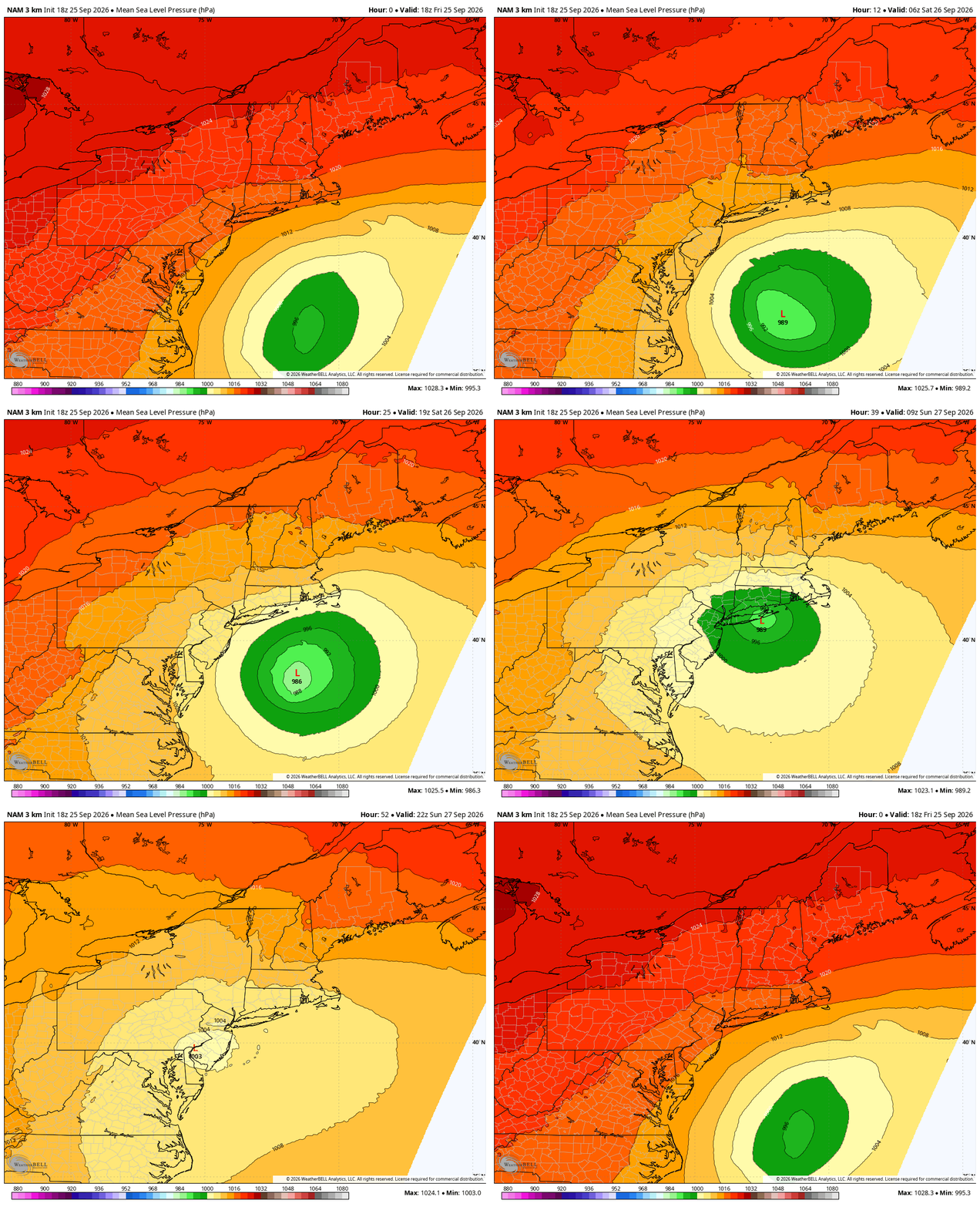
The storm becomes vertically stacked, slows down, then begins to drift or retrograde back toward the west/southwest.
That unusual motion allows Atlantic moisture to wrap farther inland.
Periods of steady light to moderate rain are increasingly likely Saturday night into Sunday, especially south and east of Albany.
RAINFALL
The highest totals remain favored across the Mid-Hudson Valley and points southeast.
Current expectations:
• Mid-Hudson Valley / eastern Catskills / I-84 corridor: generally 1–2 inches, locally higher
• NYC / Long Island: substantially heavier, now generally 3-6 inches over the full event
There remains a low-end possibility for localized totals approaching 3 inches near I-84 if persistent bands rotate through.
Despite those totals, widespread flash flooding is not expected because the rainfall occurs over a long period and conditions have been relatively dry.
WIND
The strongest winds will occur Friday night through Saturday night.
For most of the Hudson Valley:
• Gusts generally 25–40 MPH
• 35–40 MPH gusts become more likely across the Mid-Hudson Valley, southern Catskills and exposed terrain
• 40–50 MPH gusts remain most favored farther southeast into NW Connecticut and closer to the coast
There is a much stronger wind field several thousand feet above us, but forecast soundings continue to show a deep stable layer/inversion.
That should prevent most of those stronger winds from efficiently mixing to the ground.
So while some model maps look aggressive, widespread 50–60 MPH gusts across the Hudson Valley are still not the expectation.
The bigger concern is duration.
Fully leafed trees + wet ground + many hours of 30–40 MPH gusts can still produce scattered limbs, isolated trees down and some power outages.
COASTAL FLOODING — CONCERN INCREASING
This has become a more significant part of the storm.
Saturday into Sunday now looks like the peak coastal-flood period, coinciding with the full moon and the highest astronomical tides.
Widespread moderate to locally major coastal flooding is now expected across portions of Long Island and the lower NYC boroughs.
Minor to locally moderate flooding is expected along parts of the lower Hudson and western Long Island Sound.
Closer to home, minor tidal flooding is expected along the Hudson near Poughkeepsie Saturday.
Large surf, beach erosion and dangerous coastal conditions will continue through the weekend.
BOTTOM LINE
Friday evening: Increasing clouds and wind; rain still mainly southeast
Saturday morning: Some areas may still salvage a decent portion of the day
Saturday afternoon/evening: Rain expands northwest, especially across the Mid-Hudson Valley
Saturday night–Sunday: Highest confidence period for widespread rain
Wind: Long-duration 25–40 MPH gust regime inland, stronger southeast/coast
Flooding: Limited inland concern, much greater concern along the coast
Sunday night–Monday: Storm slowly weakens but may continue to spin nearby before finally departing Tuesday
The storm itself is no longer the question.
For the Hudson Valley, the remaining challenge is exactly how far northwest the heavier rain shield gets — and how quickly it gets there.
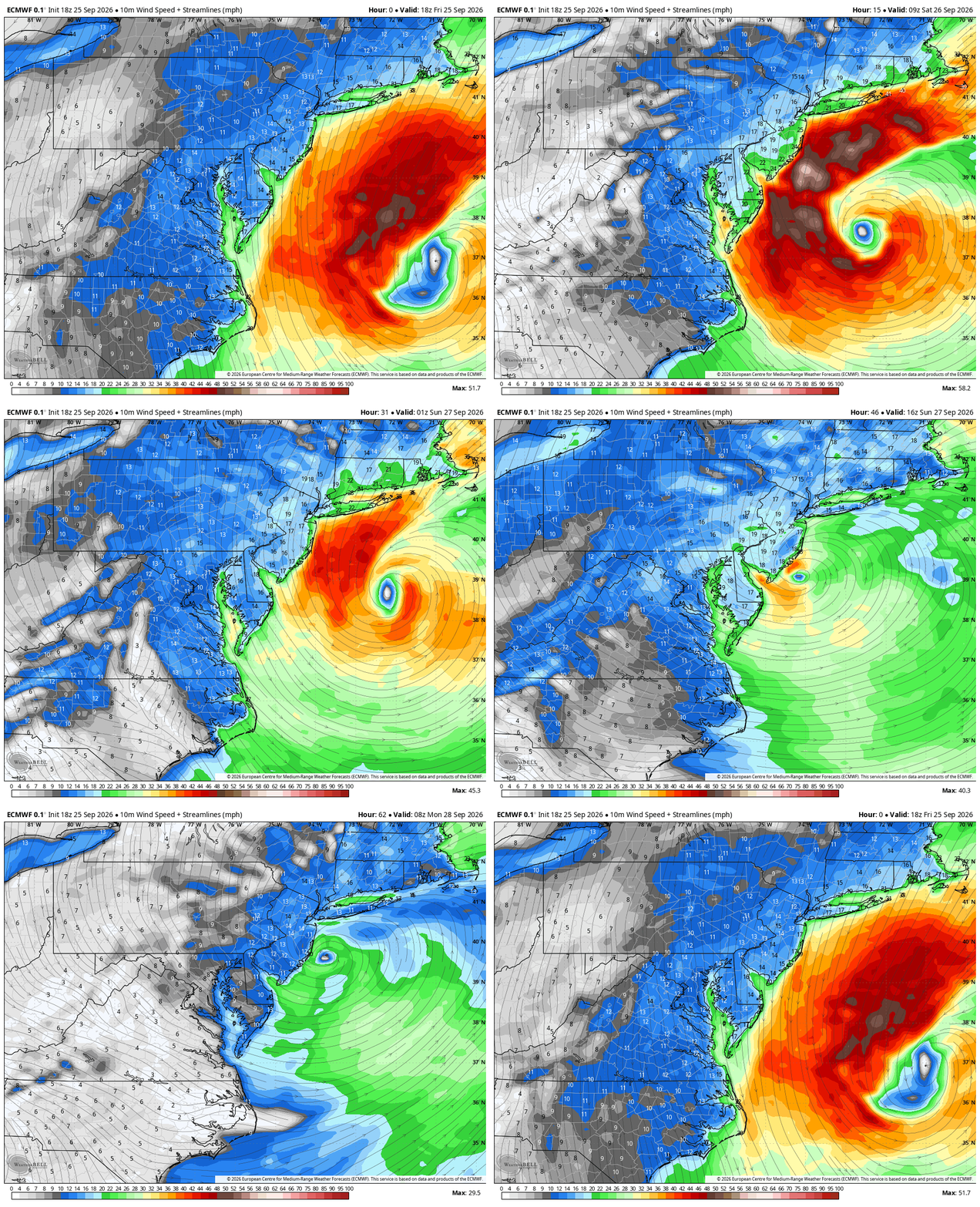
Newest NAM below is a northern outlier on its track and strength, EURO and GFS remain further south and weaker. We will continue to monitor the latest data and update as needed.

NOR’EASTER UPDATE — THE BIG QUESTION NOW: HOW MUCH OF SATURDAY CAN WE SALVAGE?

The coastal storm we’ve been tracking for nearly 10+ days publicly and even longer behind the scenes is now developing off the East Coast. Major coastal erosion and flooding is ongoing from the Outer Banks of NC to Long Island. These areas have another few days of battering from high seas, astronomically high tides and gusty winds.
Check out that track on the latest euro, western approach a near landfall, a loop and up the coast and out sea. This would be a prolific track for a winter storm. The latest NAM showing a similar track as models begin to converge on an idea. We will best more graphics in the comments.
For the Hudson Valley, the remaining challenge is much more specific:
Exactly how quickly does the western edge of the rain shield reach us — and where does it set up during the day Saturday?
If you have Saturday plans, this remains a surprisingly difficult forecast.
FRIDAY — MOST OF THE HUDSON VALLEY STILL HAS TIME
Today will become increasingly cloudy and breezy as the pressure gradient tightens between strong high pressure over Canada and the developing coastal storm.
North/northeast winds will increase, with gusts generally 20–30 MPH.
Rain will begin advancing toward the region from the southeast, but this is not going to arrive everywhere at once.
Some showers could begin reaching our southeastern zones later today and tonight, while locations farther north and west may remain dry considerably longer.
And that sharp northwest progression becomes extremely important heading into Saturday.
SATURDAY — THIS IS THE FORECAST BATTLE ZONE
We’ve included rainfall projections from the NAM, GFS and Euro through roughly 5 PM Saturday.
They tell three noticeably different stories.
The NAM is the slowest. It keeps meaningful rainfall southeast of much of the Hudson Valley through a significant portion of Saturday.
The GFS gets precipitation farther northwest but still maintains a fairly pronounced cutoff through our region.
The Euro is more aggressive, bringing steadier rainfall farther fg with a similar forecasting challenge here — just with rain.
There will likely be a very sharp western edge to the Atlantic moisture shield.
Move that boundary 30–50 miles east and portions of the Hudson Valley could squeeze out a surprisingly decent chunk of Saturday.
Move it 30–50 miles west and steady rain arrives substantially earlier.
That is why we’re hesitant to simply label Saturday a “washout” for everyone.
LOCATION WILL MATTER
Right now, the farther south and east you are, the lower your chances of salvaging Saturday.
Dutchess, Putnam, Orange and southeastern Ulster County have a considerably greater chance of dealing with periods of rain during the day.
Move farther north and west into the Catskills, upper Hudson Valley and toward the Capital Region, and the opportunity for a prolonged dry period increases.
For the central Mid-Hudson Valley?
It’s a tough call.
Morning plans probably have a better chance than afternoon plans, but even that will depend heavily on how quickly the rain shield advances northwest.
DON’T CONFUSE A DRY SATURDAY WITH A MISS
This is important.
Even the models that are relatively dry across portions of our region Saturday eventually bring more substantial rainfall into the Hudson Valley.
That’s because the nor’easter doesn’t simply race northeast and leave.
The storm becomes trapped beneath the blocking pattern, slows dramatically, then begins to meander or retrograde west/southwest toward the coast.
As that happens, Atlantic moisture wraps farther inland.
So there are really two separate questions:
How much rain reaches you by Saturday afternoon?
Still uncertain.
Does a larger portion of the Hudson Valley eventually get rain this weekend?
Much more likely.
TOTAL RAINFALL
The GFS and Euro ultimately paint a much wetter picture than their Saturday-afternoon snapshots.
For the Mid-Hudson Valley and eastern Catskills, 1–2 inches remains a reasonable general expectation, with locally greater amounts possible depending on where persistent bands rotate.
Amounts fall off considerably heading northwest.
Meanwhile, rainfall increases dramatically toward Connecticut, Long Island and southern New England.
Widespread river flooding is not currently expected across the Hudson Valley. Although some minor tidal flooding near Poughkeepsie is possible.
Dry overall conditions should allow us to handle most of this rainfall especially giving it falls over a longer period of time. Some localized ponding and poor-drainage flooding remain possible under heavier bands.
WIND — STRONG WINDS ALOFT, BUT AN IMPORTANT LIMITING FACTOR
There’s an impressive wind field associated with this storm.
A 40–60 knot low-level jet develops overhead and particularly to our southeast.
Normally those numbers grab attention.
But there’s an important limiting factor:
An inversion is expected around the 850–750mb layer.
Essentially, we have a layer of stable air acting like a lid, making it difficult to efficiently transport all of that stronger wind down to ground level.
That’s the same feature we were discussing yesterday.
So despite some impressive wind speeds above our heads, widespread 50–60 MPH surface gusts are not currently expected across the Hudson Valley.
For most of our region, we’re looking more toward:
– 25–40 MPH gusts
with the greatest opportunity for stronger gusts across the Mid-Hudson Valley, eastern Catskills, Taconics, Berkshires and NW Connecticut.
There is still a caveat.
Our trees remain fully leafed, and the ground will become wetter as the storm progresses.
That means weakened trees and limbs can occasionally come down at lower wind speeds than we’d typically worry about later in the fall.
COASTAL IMPACTS REMAIN MUCH MORE SIGNIFICANT
The coast is dealing with an entirely different level of impact.
Long-duration northeast winds, large waves and Saturday’s full moon will combine through multiple high-tide cycles.
Official forecasts now highlight the potential for moderate coastal flooding across portions of Long Island, with some locations in the South Shore Bays showing increasing potential for major coastal flooding.
Significant beach erosion, high surf and dangerous conditions along the immediate coast are also expected.
BOTTOM LINE — SATURDAY PLANS
If you’re asking us right now whether to cancel Saturday plans across the Hudson Valley:
We wouldn’t make that blanket call yet.
South/east: Rain arriving earlier is increasingly likely.
Central Hudson Valley: Very track-dependent. Saturday morning has a better chance of staying usable than later in the day.
North/west: Better opportunity to salvage a substantial portion of Saturday if the slower progression verifies.
Saturday night into Sunday: Chances increase considerably for more widespread rain as the storm begins its unusual loop.
This is one of those forecasts where 30 or 40 miles matters.
Just like trying to place the heavy snow band during a winter nor’easter, getting the storm track generally correct isn’t enough.
We need to nail the western edge of the precipitation shield.
Sunday and Monday are really just the worst of the weather days, Sunday especially as the core of the storms moisture impacts the entire region, guidance doesn’t have rain fully pulling out of the region until late Monday- so really today and for some the first half of Saturday is the best we do weather wise.
And right now, that edge runs directly through the Hudson Valley

Unsettled Sunday… Continues into Monday

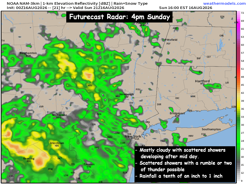
After a beautiful Saturday… we’ll have a frontal trough pushing into the eastern part of the country. It will spread clouds and scattered rain showers into NY and the Northeast. The scattered showers should reach the Hudson Valley between 12pm and 6pm… earlier west of the Hudson River. The precipitation shield looks to be disorganized and weak… so the showers should be mainly light and scattered in nature. The scattered rain showers could also contain a rumble or two of thunder… but we do not currently expect any storms to become severe. The clouds and scattered showers will keep temperatures in the upper 70s to near 80° for highs.
 
The clouds & scattered rain showers will be with us through much of the evening hours, before the precipitation moves to our south and east. It’s possible that another band of scattered showers and T-Storms develops Monday afternoon, something that will need to be monitored. Highs on Monday should climb into the low and mid 80s.
 
Make sure you keep the umbrella handy for the afternoon hours, as the moisture gradually creeps in from west to east. We’ll share updates as appropriate… Have a great day!
-Bill

Sunday Weather Discussion : Increasing clouds & humid.

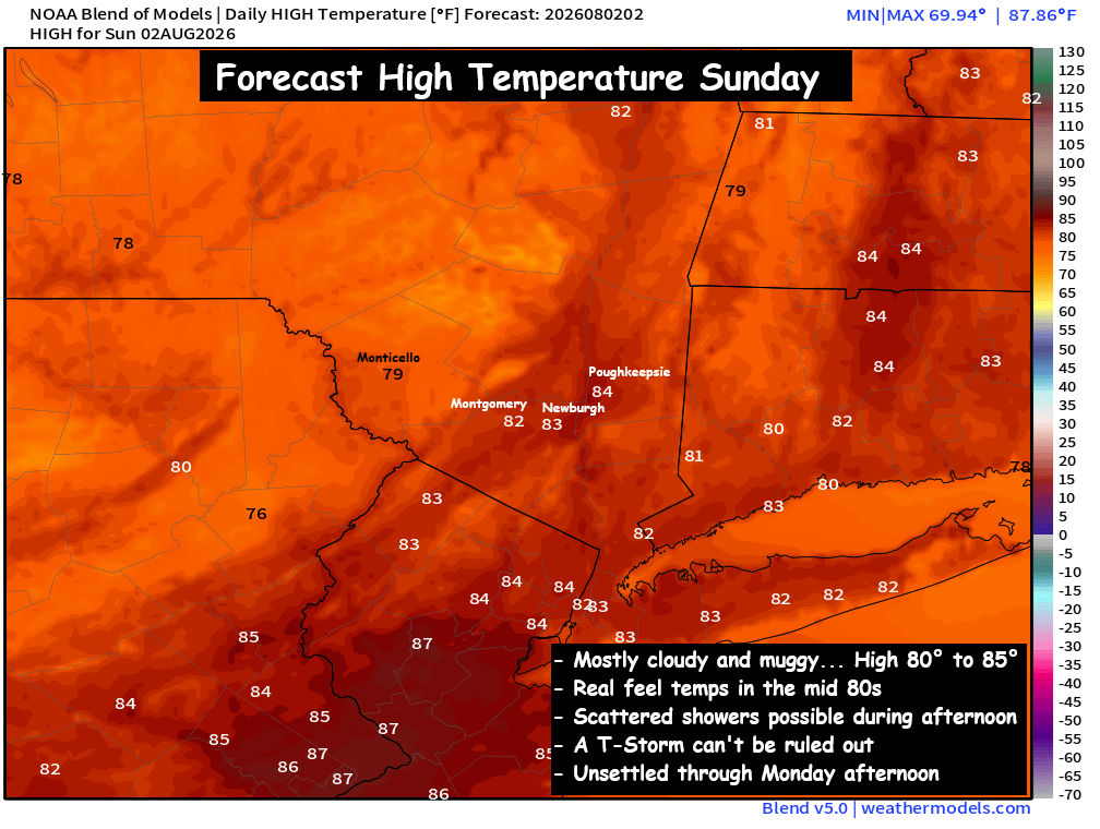
Another weak upper level trough will interact with a low pressure system over the Ohio Valley, and begin pushing moisture up into the Hudson Valley and Northeast on Sunday. Expect mostly cloudy skies… and muggy conditions. Afternoon highs should reach the low 80s.
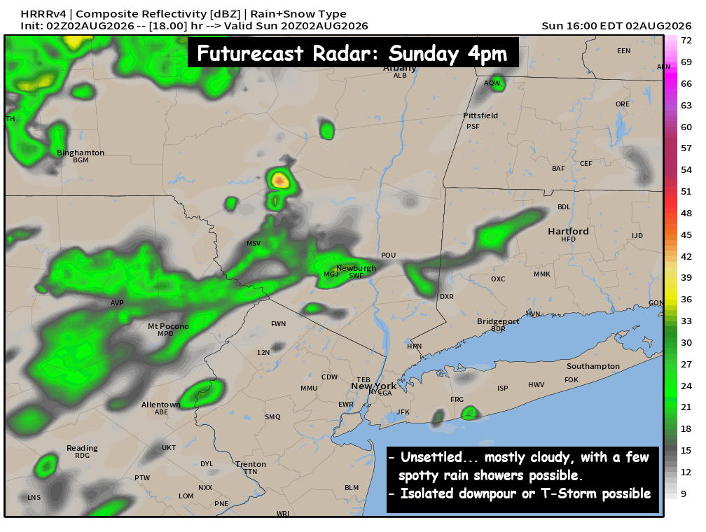
A few scattered showers could develop and move through the region during the late morning and early afternoon hours. The best chance for showers will be in the Catskills. A rumble of thunder or two can’t be ruled out… along with one or two localized downpours.
 
Sunday won’t be a washout… as the steadiest and heaviest rain will be well NW of our region. But the moisture and cloudiness will keep us unsettled and humid through the day. Be sure to plan for the possibility of a scattered shower or two if you have outdoor plans.

HVW Recap : Storm History – Rainfall Totals 7/28 – 7/30

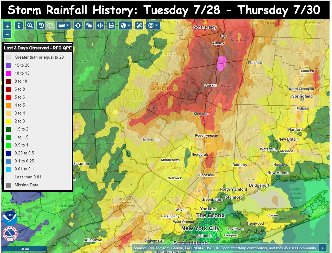
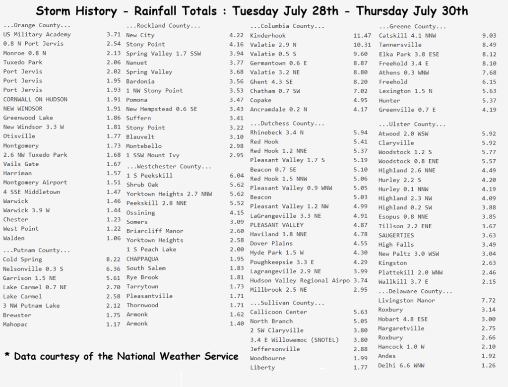
A record-breaking storm for portions of the Hudson Valley is now in the books. Some locations received nearly a foot of rain in less than 24 hours, causing severe flash flooding in parts of Columbia, Greene, Rensselaer, and Albany counties. Highest rainfall totals in our area include:
– Kinderhook: 11.47″ – Valatie: 10.31″ – Catskill: 9.03″
– Germantown: 8.87″ – Tannersville: 8.49″ – Cold Spring: 8.22″
We tracked this storm for several days and tried to highlight the complexity and potential severity of the situation. That a slow-moving low pressure would be captured by an upper-level trough, causing the low pressure to stall out. That when the storm stalled, the area of rainfall would also stall… and begin to pivot over the same locations, for many hours. This would likely result in an area of torrential rainfall with totals over 6″ possible… and even discussed that some guidance suggested localized pockets of 10″ of rain.
 
The trouble is that we couldn’t pinpoint exactly where this would happen. We felt strongly that it would be somewhere in eastern NY or western New England. Current technology cannot pinpoint where bands of excessive rainfall will occur, but we can forecast general regions with some degree of accuracy, so that’s what we try to do at HVW. We tried to drive home the idea that we’re all going to see a soaking rainfall… but that within our area, some areas are likely to receive excessive (potentially flooding) rains. Our goal is to provide viewers with the information needed to make informed decisions, to hopefully save time, money, property and most importantly… lives.
 
We hope everyone made it through the storm safely, and remains safe during the cleanup in the heavily impacted areas. Please feel free to share images and local reports in the comments below. Please be aware that the data from the National Weather Service offices may be incomplete. Thank you all for your continued support!