Morning! Good old fashion weather roller coaster over the next 24 hours!
Synopsis for those on the go-
Unsettled today with rounds of showers and some heavier downpours possible, but the main concern comes late this afternoon and evening.
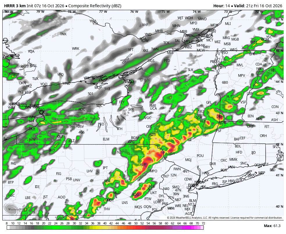
– A fast-moving line of showers/storms is expected to cross the region roughly 5–8 PM, with the potential for a quick burst of 40–50+ MPH wind gusts and isolated tree/power issues.
– Temperatures may still be near 70° in parts of the southern Hudson Valley this evening before crashing behind the front.
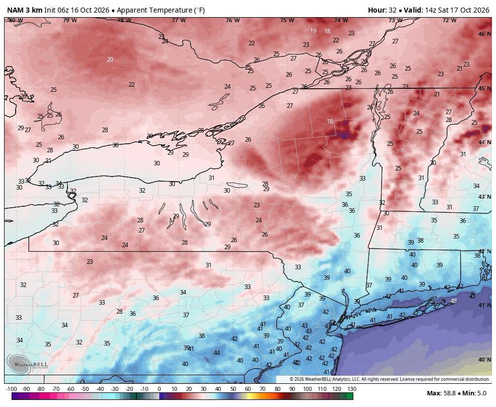
– Saturday turns sharply colder and blustery, with highs mainly in the 40s and feels-like temperatures in the 20s and 30s during the morning.
– A few flakes are even possible across the highest terrain late tonight into Saturday morning.
We’re also keeping an eye on next week for the possibility of a sneaky coastal system trying to develop along the offshore frontal boundary.
Nerd Alert below for the full breakdown.
BIG FRIDAY FLIP — SHOWERS TODAY, SQUALL LINE THIS EVENING, THEN A RUDE SATURDAY MORNING
We’ve got quite the weather transition ahead over the next 24 hours.
Today will be unsettled from the start, with periods of rain and scattered showers moving through the region well before the main cold front arrives. Some areas could even hear a rumble of thunder this morning, and a few heavier downpours are possible.
There will also be breaks between showers, and temperatures will respond quickly wherever we get some drying or filtered sunshine.
A surge of mild air ahead of the front will push temperatures well into the 60s, with portions of the southern Hudson Valley still sitting in the upper 60s to near 70° late this afternoon and early this evening.
Then comes the main event.
5–8 PM — WATCHING A FAST-MOVING SQUALL LINE
A narrow line of showers and thunderstorms is expected to develop along the approaching cold front and sweep west to east through the region late this afternoon and evening.
The atmosphere won’t be especially unstable, but there is a tremendous amount of wind just above the surface, with 50–60 knot wind shear available to a low-topped line of storms.
That means stronger showers or thunderstorms may be capable of briefly transferring some of that momentum downward.
The primary concern is a quick burst of damaging wind.
A reasonable timing progression:
– Delaware / Sullivan / western Catskills: late afternoon into early evening
– Ulster / Greene / Orange / Mid-Hudson Valley: roughly 5–7 PM
– Dutchess / Columbia / Putnam / Rockland / Westchester: roughly 6–8 PM
The line itself may only last 15–30 minutes at any one location.
During that window:
– Sudden gusts potentially 40–50+ MPH
– Brief heavy rain
– A few thunderstorms
– Isolated downed limbs or power outages
Even where thunderstorms don’t fully develop, the frontal passage itself could produce a quick burst of 35–45 MPH wind gusts.
So don’t judge this front by how much lightning you see.
This is much more of a wind-driven frontal passage than a classic warm-season thunderstorm event.
THEN THE TEMPERATURE FALLS OFF A CLIFF
Some southern locations could still be near 70° early this evening.
By Saturday morning, many locations will be in the 30s, with 40s mainly confined to the lower elevations and far southern portions of the region.
Higher elevations could fall toward or below freezing.
Add northwest winds gusting 25–35 MPH, and it will feel substantially colder.
Saturday morning apparent temperatures could fall into:
– 20s across the Catskills and higher terrain
– Upper 20s to 30s across much of the Hudson Valley
– Around 40° or lower even across portions of our southern counties
SATURDAY — COLD, BLUSTERY & RAW
Saturday will likely be one of the coldest-feeling Saturdays we’ve had since early spring.
Actual afternoon temperatures struggle through the 40s in the valleys, with only 30s to lower 40s across the higher terrain.
Northwest winds continue gusting 25–35 MPH, keeping apparent temperatures in the 30s for much of the day and potentially only the 20s across the mountains.
– A few snow showers or flurries are possible across the highest terrain late tonight into Saturday morning.
Sunday is a slight warm up with low 50’s and calm winds.
BOTTOM LINE
– Periods of rain and showers possible throughout today
– Main frontal passage roughly 5–8 PM
– Brief damaging wind gusts possible with the line
– Temperatures plunge tonight
– Saturday morning feels-like values in the 20s and 30s
– Blustery and cold Saturday, highs mainly in the 40s
– A few high-elevation snow showers or flurries possible
It’s an unsettled day overall — with the late-day frontal passage being the period most likely to pack a punch.
LOOKING AHEAD
We’re also keeping an eye on next week for the potential of another sneaky coastal system trying to develop along the stalled frontal boundary offshore.
It’s very early and confidence is low, but those offshore boundaries can occasionally become the focus for secondary low pressure development.
Nothing to sound alarms over at this stage — just something we’ll be watching as the pattern evolves.
-Alex