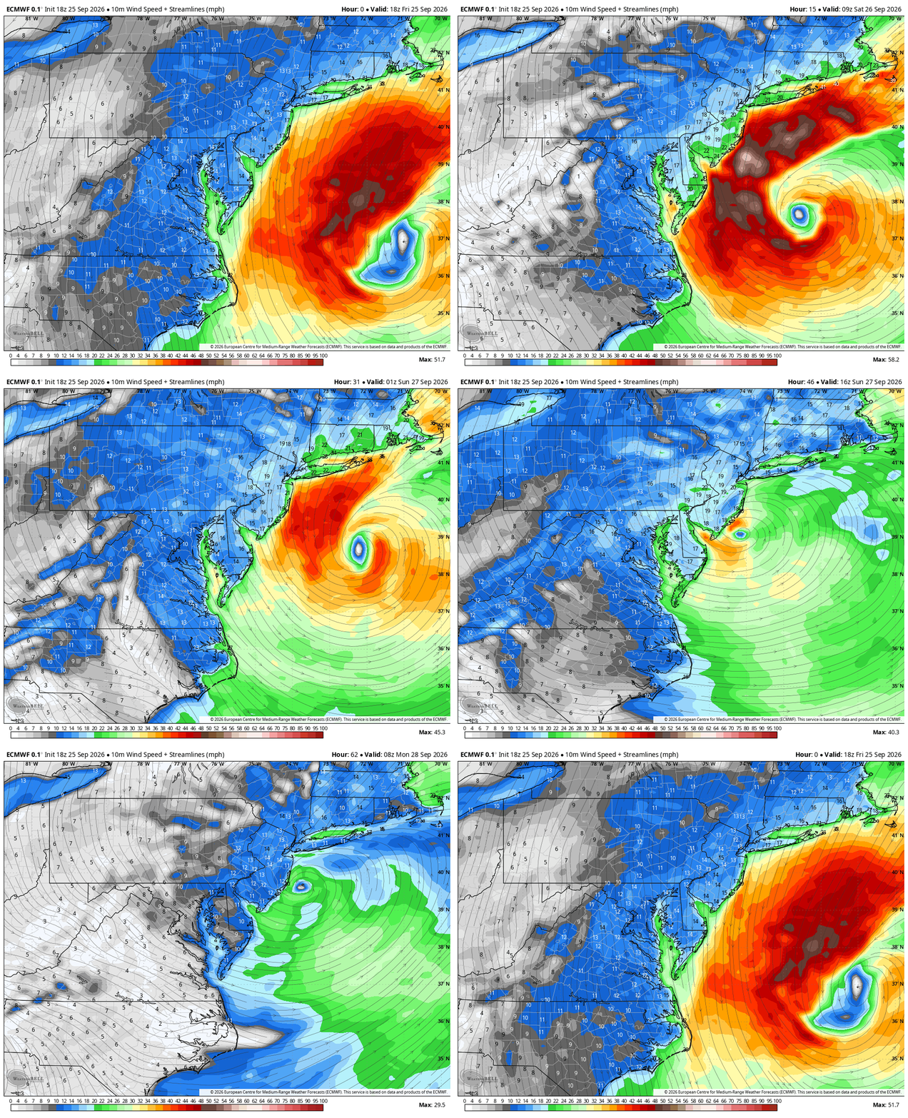
The coastal storm we’ve been tracking for nearly 10+ days publicly and even longer behind the scenes is now developing off the East Coast. Major coastal erosion and flooding is ongoing from the Outer Banks of NC to Long Island. These areas have another few days of battering from high seas, astronomically high tides and gusty winds.
Check out that track on the latest euro, western approach a near landfall, a loop and up the coast and out sea. This would be a prolific track for a winter storm. The latest NAM showing a similar track as models begin to converge on an idea. We will best more graphics in the comments.
For the Hudson Valley, the remaining challenge is much more specific:
Exactly how quickly does the western edge of the rain shield reach us — and where does it set up during the day Saturday?
If you have Saturday plans, this remains a surprisingly difficult forecast.
FRIDAY — MOST OF THE HUDSON VALLEY STILL HAS TIME
Today will become increasingly cloudy and breezy as the pressure gradient tightens between strong high pressure over Canada and the developing coastal storm.
North/northeast winds will increase, with gusts generally 20–30 MPH.
Rain will begin advancing toward the region from the southeast, but this is not going to arrive everywhere at once.
Some showers could begin reaching our southeastern zones later today and tonight, while locations farther north and west may remain dry considerably longer.
And that sharp northwest progression becomes extremely important heading into Saturday.
SATURDAY — THIS IS THE FORECAST BATTLE ZONE
We’ve included rainfall projections from the NAM, GFS and Euro through roughly 5 PM Saturday.
They tell three noticeably different stories.
The NAM is the slowest. It keeps meaningful rainfall southeast of much of the Hudson Valley through a significant portion of Saturday.
The GFS gets precipitation farther northwest but still maintains a fairly pronounced cutoff through our region.
The Euro is more aggressive, bringing steadier rainfall farther fg with a similar forecasting challenge here — just with rain.
There will likely be a very sharp western edge to the Atlantic moisture shield.
Move that boundary 30–50 miles east and portions of the Hudson Valley could squeeze out a surprisingly decent chunk of Saturday.
Move it 30–50 miles west and steady rain arrives substantially earlier.
That is why we’re hesitant to simply label Saturday a “washout” for everyone.
LOCATION WILL MATTER
Right now, the farther south and east you are, the lower your chances of salvaging Saturday.
Dutchess, Putnam, Orange and southeastern Ulster County have a considerably greater chance of dealing with periods of rain during the day.
Move farther north and west into the Catskills, upper Hudson Valley and toward the Capital Region, and the opportunity for a prolonged dry period increases.
For the central Mid-Hudson Valley?
It’s a tough call.
Morning plans probably have a better chance than afternoon plans, but even that will depend heavily on how quickly the rain shield advances northwest.
DON’T CONFUSE A DRY SATURDAY WITH A MISS
This is important.
Even the models that are relatively dry across portions of our region Saturday eventually bring more substantial rainfall into the Hudson Valley.
That’s because the nor’easter doesn’t simply race northeast and leave.
The storm becomes trapped beneath the blocking pattern, slows dramatically, then begins to meander or retrograde west/southwest toward the coast.
As that happens, Atlantic moisture wraps farther inland.
So there are really two separate questions:
How much rain reaches you by Saturday afternoon?
Still uncertain.
Does a larger portion of the Hudson Valley eventually get rain this weekend?
Much more likely.
TOTAL RAINFALL
The GFS and Euro ultimately paint a much wetter picture than their Saturday-afternoon snapshots.
For the Mid-Hudson Valley and eastern Catskills, 1–2 inches remains a reasonable general expectation, with locally greater amounts possible depending on where persistent bands rotate.
Amounts fall off considerably heading northwest.
Meanwhile, rainfall increases dramatically toward Connecticut, Long Island and southern New England.
Widespread river flooding is not currently expected across the Hudson Valley. Although some minor tidal flooding near Poughkeepsie is possible.
Dry overall conditions should allow us to handle most of this rainfall especially giving it falls over a longer period of time. Some localized ponding and poor-drainage flooding remain possible under heavier bands.
WIND — STRONG WINDS ALOFT, BUT AN IMPORTANT LIMITING FACTOR
There’s an impressive wind field associated with this storm.
A 40–60 knot low-level jet develops overhead and particularly to our southeast.
Normally those numbers grab attention.
But there’s an important limiting factor:
An inversion is expected around the 850–750mb layer.
Essentially, we have a layer of stable air acting like a lid, making it difficult to efficiently transport all of that stronger wind down to ground level.
That’s the same feature we were discussing yesterday.
So despite some impressive wind speeds above our heads, widespread 50–60 MPH surface gusts are not currently expected across the Hudson Valley.
For most of our region, we’re looking more toward:
– 25–40 MPH gusts
with the greatest opportunity for stronger gusts across the Mid-Hudson Valley, eastern Catskills, Taconics, Berkshires and NW Connecticut.
There is still a caveat.
Our trees remain fully leafed, and the ground will become wetter as the storm progresses.
That means weakened trees and limbs can occasionally come down at lower wind speeds than we’d typically worry about later in the fall.
COASTAL IMPACTS REMAIN MUCH MORE SIGNIFICANT
The coast is dealing with an entirely different level of impact.
Long-duration northeast winds, large waves and Saturday’s full moon will combine through multiple high-tide cycles.
Official forecasts now highlight the potential for moderate coastal flooding across portions of Long Island, with some locations in the South Shore Bays showing increasing potential for major coastal flooding.
Significant beach erosion, high surf and dangerous conditions along the immediate coast are also expected.
BOTTOM LINE — SATURDAY PLANS
If you’re asking us right now whether to cancel Saturday plans across the Hudson Valley:
We wouldn’t make that blanket call yet.
South/east: Rain arriving earlier is increasingly likely.
Central Hudson Valley: Very track-dependent. Saturday morning has a better chance of staying usable than later in the day.
North/west: Better opportunity to salvage a substantial portion of Saturday if the slower progression verifies.
Saturday night into Sunday: Chances increase considerably for more widespread rain as the storm begins its unusual loop.
This is one of those forecasts where 30 or 40 miles matters.
Just like trying to place the heavy snow band during a winter nor’easter, getting the storm track generally correct isn’t enough.
We need to nail the western edge of the precipitation shield.
Sunday and Monday are really just the worst of the weather days, Sunday especially as the core of the storms moisture impacts the entire region, guidance doesn’t have rain fully pulling out of the region until late Monday- so really today and for some the first half of Saturday is the best we do weather wise.
And right now, that edge runs directly through the Hudson Valley