COASTAL STORM UPDATE — AFTER NEARLY 10 DAYS OF TRACKING OUR STORM HAS ARRIVED-WAVES OF RAIN, WIND AND A LONG-DURATION WEEKEND EVENT
The nor’easter is now well established off the Mid-Atlantic coast and continues to strengthen while slowly lifting north.
For the Hudson Valley and Catskills, this remains a long-duration event rather than one continuous wall of rain. One of those first waves of heavier and steadier rain is pushing through the region at this early hour. What you’re seeing outside right now, won’t necessarily be the conditions all day, models continue to support lulls later this morning and into the afternoon, more below.
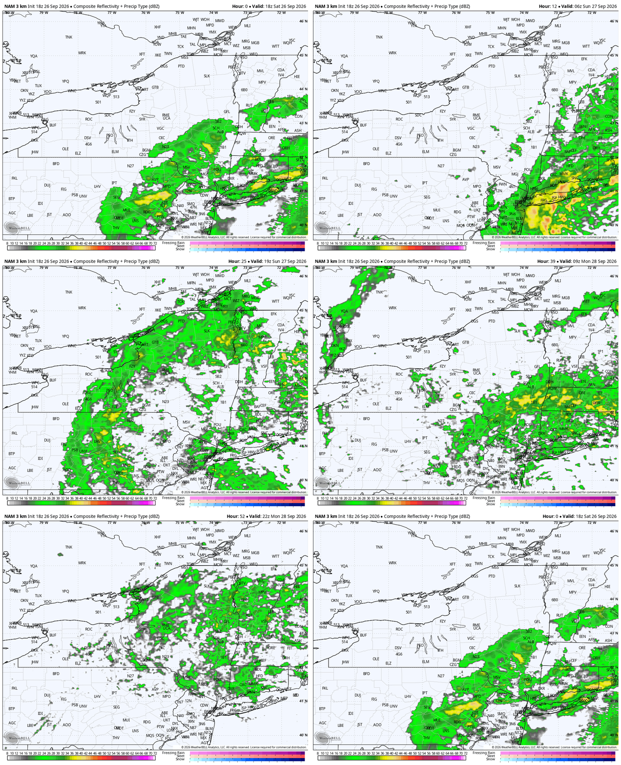
The biggest thing to understand over the next 48 hours is that conditions will come in waves.
SATURDAY LATE MORNING / AFTERNOON
There is a legitimate opportunity for rainfall to ease or become much more scattered for a time.
Some locations may even turn mainly dry between bands, particularly farther north and west.
This does NOT mean the storm is ending.
It’s simply a temporary break as the circulation reorganizes and the surface low begins its westward turn.
So if you have plans today, there may be windows where conditions are considerably more manageable than the radar or broader storm headlines would suggest.
SATURDAY NIGHT INTO SUNDAY MORNING
This is the period we are watching for the most widespread and organized rainfall across the Hudson Valley.
As the storm pivots west toward the New Jersey coast, deeper Atlantic moisture wraps farther inland.
A broader shield of steady light to moderate rain should expand west and northwest overnight.
Some heavier bands are possible, especially from the eastern Catskills and Mid-Hudson Valley eastward.
The period from roughly overnight through Sunday morning, and potentially into late Sunday morning or early afternoon, looks like the best opportunity for the steadiest rainfall across much of the region.
SUNDAY AFTERNOON
Once again, rainfall may become less organized.
Instead of a solid rain shield, we may transition back toward lighter rain, showers and breaks between bands.
That said, we are not forecasting a dry Sunday afternoon everywhere.
The storm will still be sitting nearby and rotating moisture around its circulation.
SUNDAY NIGHT INTO MONDAY
As the low continues to meander and loop near the New Jersey coast, additional bands of rain may rotate back across the region Sunday evening and Sunday night.
Showers could linger into Monday before the storm finally begins getting pulled northeast and away from us Monday night into Tuesday.
So the overall theme is:
Saturday morning — periods of rain/showers
Saturday afternoon — possible lull / lighter and more scattered
Saturday night — rain becomes more widespread again
Sunday morning — steadiest and potentially heaviest inland rainfall
Sunday afternoon — more scattered/lighter again
Sunday night — additional wraparound rain possible
Monday — lingering showers gradually ending
RAIN TOTALS
There will still be a pronounced southeast-to-northwest gradient.
Highest totals are favored across:
• Westchester
• Rockland
• Putnam
• Dutchess
• eastern/southern Ulster
• eastern Catskills
• Columbia County
Amounts generally decrease farther west into:
• Sullivan
• Delaware
• western Ulster
• western Greene
For much of the Mid-Hudson Valley and eastern Catskills, storm totals of roughly 1–2.5 inches remain reasonable, with localized 3-inch totals possible where persistent bands develop.
Westchester and Rockland could also finish near or above 2 inches depending on where the heavier bands pivot.
Farther west into Delaware and Sullivan Counties, totals should be lower unless the storm’s precipitation shield pushes farther west than expected.
This rain is falling over a long period, so widespread flash flooding remains unlikely.
Poor drainage flooding, ponding and localized nuisance flooding are more likely concerns.
Minor tidal flooding is also expected along portions of the Hudson River, including around Poughkeepsie.
WIND
The wind forecast has become a little more interesting.
The strongest winds remain aloft, but daytime mixing today may be somewhat more efficient than earlier guidance suggested.
That could allow more widespread gusts of 30–40 MPH across:
• Mid-Hudson Valley
• eastern Catskills
• Columbia County
• Taconics
• exposed higher terrain
Farther south and east, including Westchester and Rockland, gusts may locally exceed 40 MPH.
The strongest winds still remain favored closer to the coast.
The important limiting factor remains the inversion.
Tonight, even though winds around 45–55 knots exist several thousand feet above us, a sharp stable layer should prevent the strongest winds from consistently reaching the surface.
So widespread 50–60 MPH gusts are still not expected inland.
But long-duration 30–40+ MPH gusts, fully foliated trees and increasingly wet soil can still produce scattered downed limbs and isolated power outages.
COUNTY-BY-COUNTY GENERAL IMPACT
Westchester / Rockland
Wettest and windiest portion of our coverage area overall. Periods of rain today, more organized rain tonight into Sunday morning, gusts frequently 30–40+ MPH with localized higher gusts possible.
Putnam / Dutchess
Periods of rain today with possible breaks this afternoon. Steadier rain develops tonight into Sunday morning. Gusts generally 30–40 MPH.
Orange / Ulster
More opportunity for dry breaks today. Rain becomes more widespread tonight into Sunday morning. Winds generally 25–40 MPH, strongest east.
Sullivan / Delaware
Farther removed from the strongest wind and heaviest rainfall. Showers possible today, with a better chance for steadier rain tonight into Sunday, but overall totals should be lower.
Greene / Columbia
Greene County will likely see a sharper rainfall gradient, especially west to east. Columbia County should see a better opportunity for steadier rain tonight into Sunday. Gusts generally 25–40 MPH, strongest in exposed areas.
BOTTOM LINE
This is not a “rains nonstop from Saturday through Monday” storm.
It is a slow-moving circulation that will repeatedly rotate bands of rain through the region.
There will be breaks.
There will be periods where radar looks much quieter.
Then another band rotates in.
The most important window for widespread rainfall across the Hudson Valley currently looks to be Saturday night into Sunday morning.
And because the storm refuses to leave, additional rounds remain possible through Sunday night and Monday. Attached is the NAM Model- simulated radar now through 2PM Monday.. again, long duration.
Hey all.. it’s been a minute, but don’t forget to Stay Calm and Weather On!
Talk more soon! Stay safe out there, I may even head to that Garlic Festival and try to support those vendors who are braving today’s weather!