Wednesday Discussion: Raw & Windy April Weather

A very raw and windy Wednesday shaping up for the Hudson Valley…

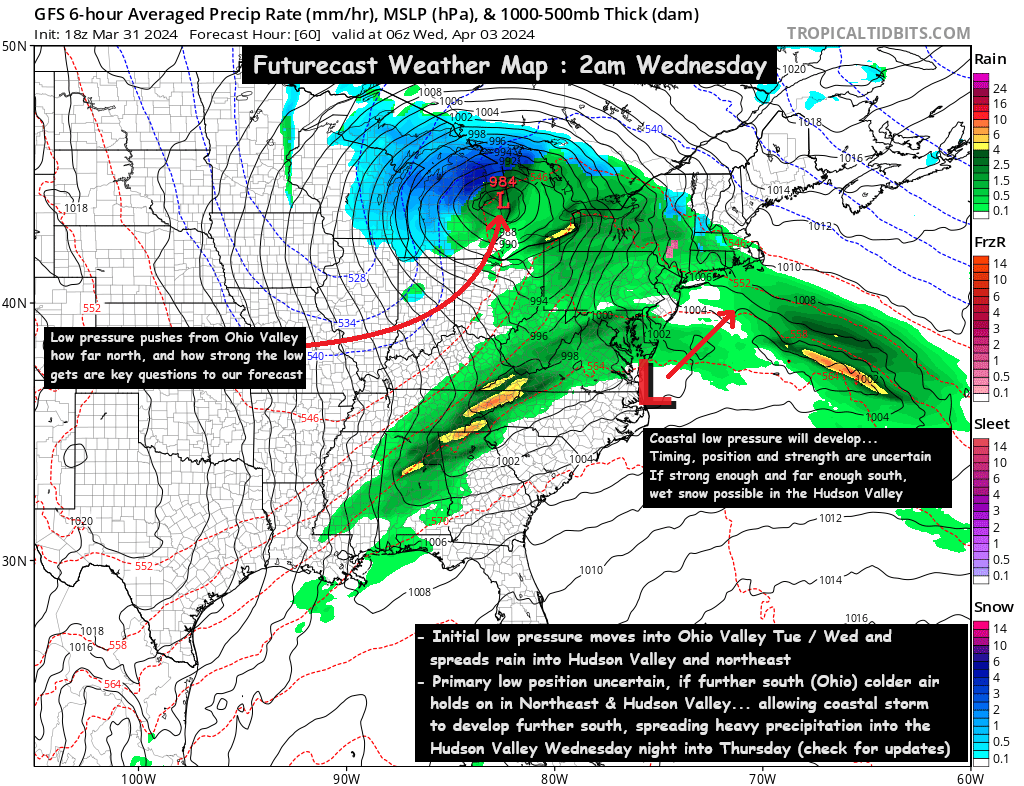
A low-pressure system near Chicago has stalled out but has sent waves of moisture eastward toward the Hudson Valley and northeast.

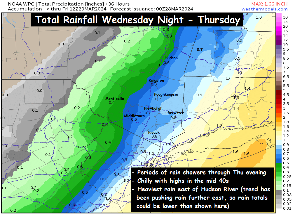
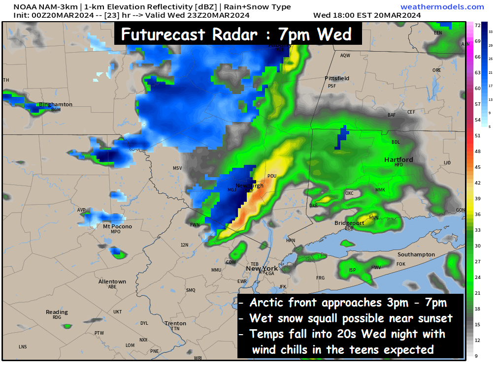
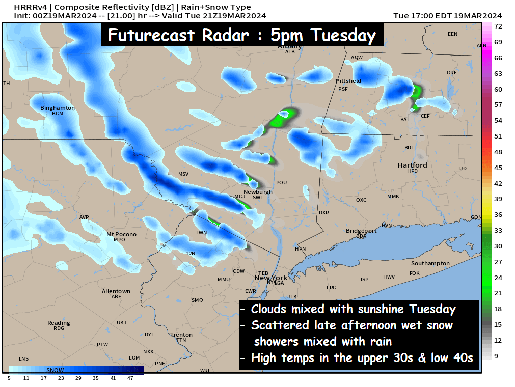
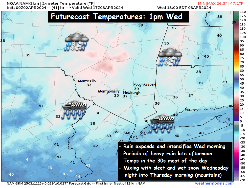
Futurecast Radar : 6am to 8pm Wednesday

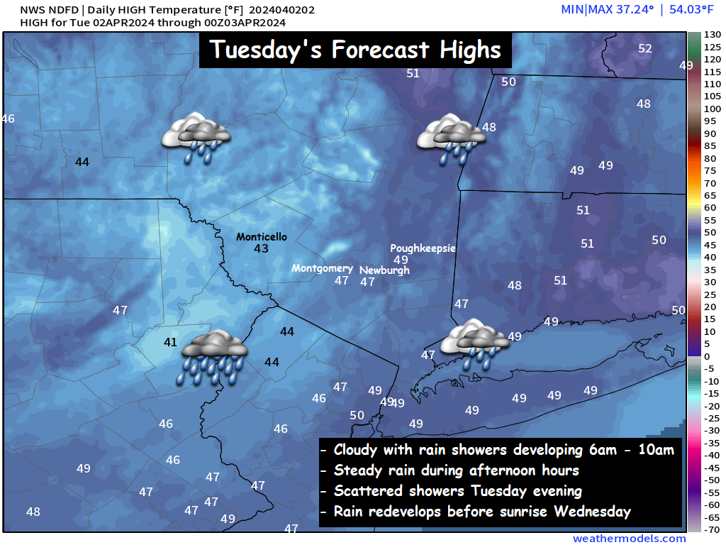
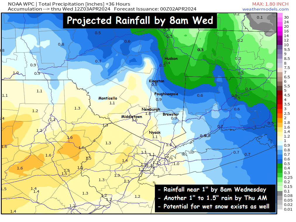
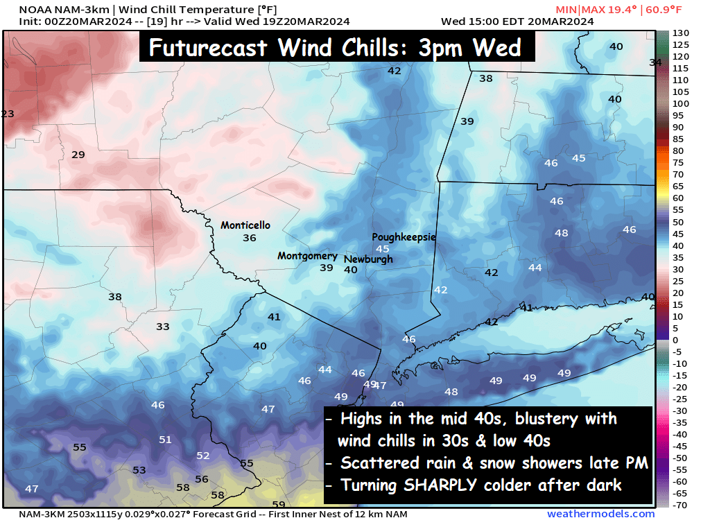
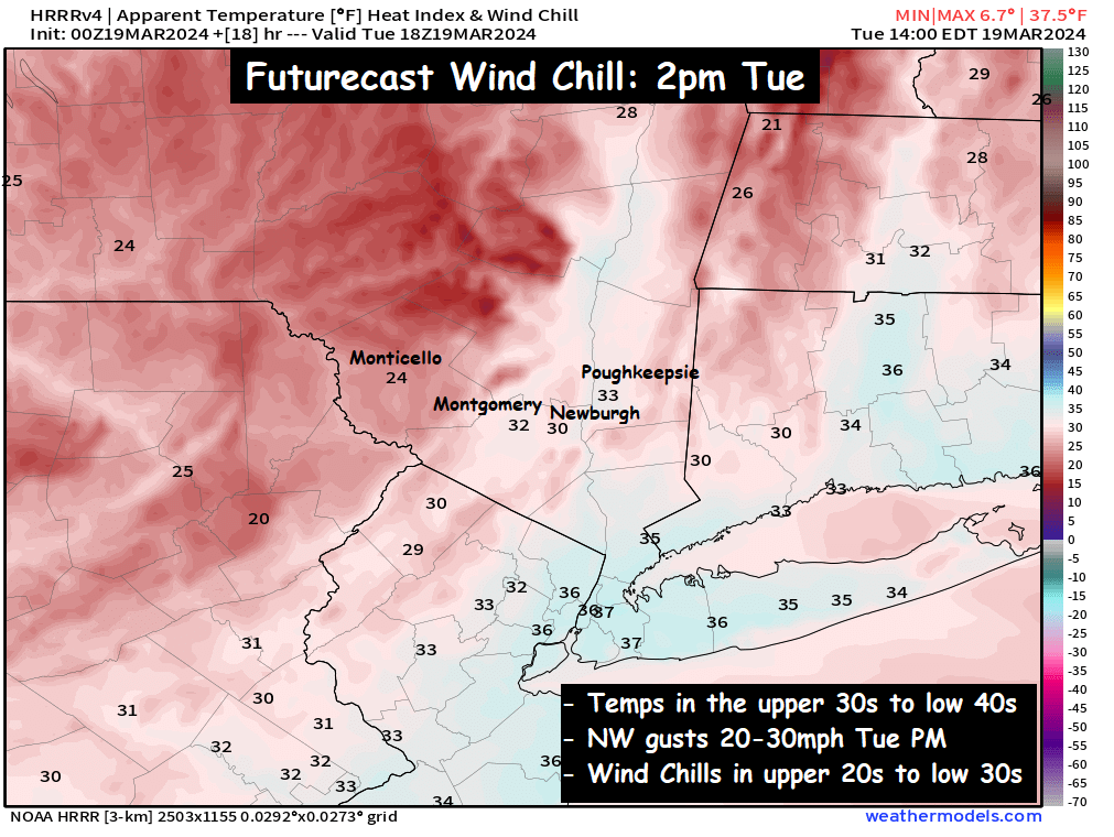
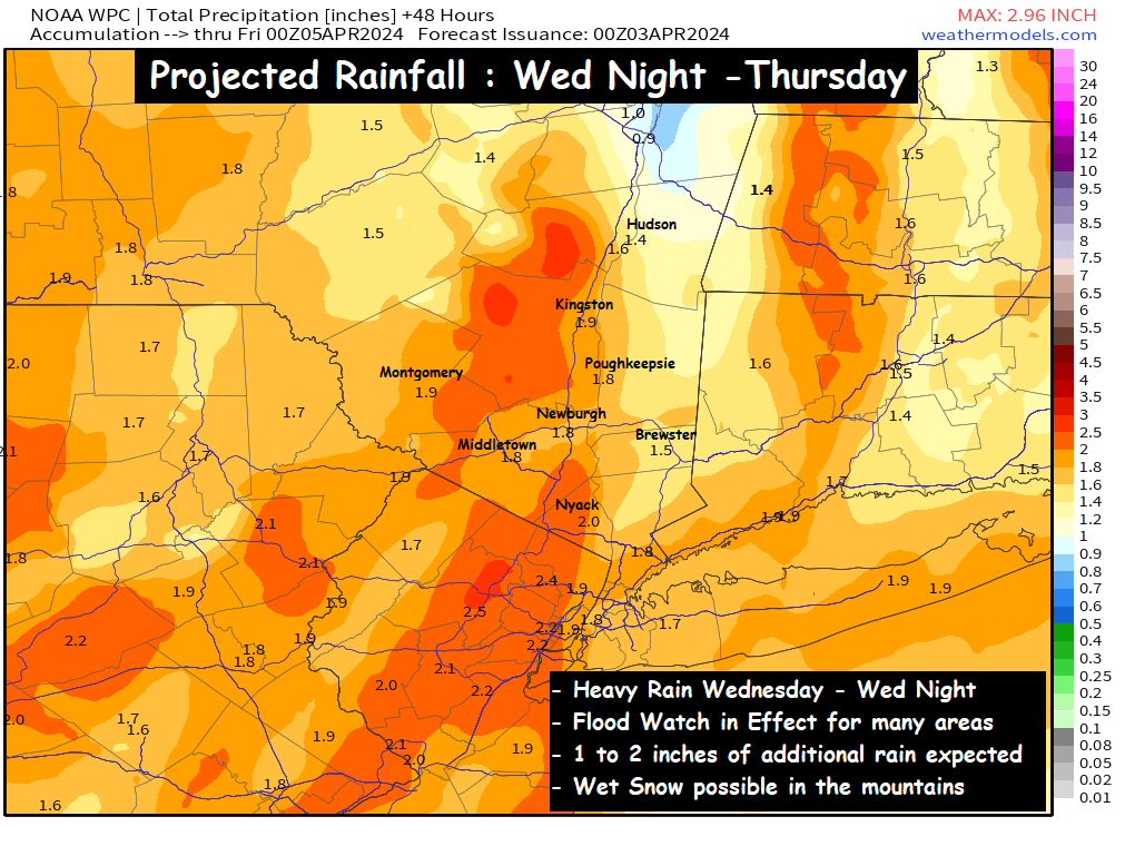
Periods of rain will move in during the morning, and be with us throughout the day.  Along with the soaking rainfall, winds will also begin to pick up out of the east ahead of the frontal boundary.  While some computer guidance projects wind gusts over 50mph, the good news is that a temperature inversion in the mid levels should prevent the strongest wind gusts from reaching the surface.  Even so, a Wind Advisory is in effect for parts of the area, so be sure to plan for a raw, blustery, soaked Wednesday.  In addition to Wind Advisories, we have many Flood Watches in effect around the valley, for another 1 to 2 inches of rainfall by Thursday afternoon…

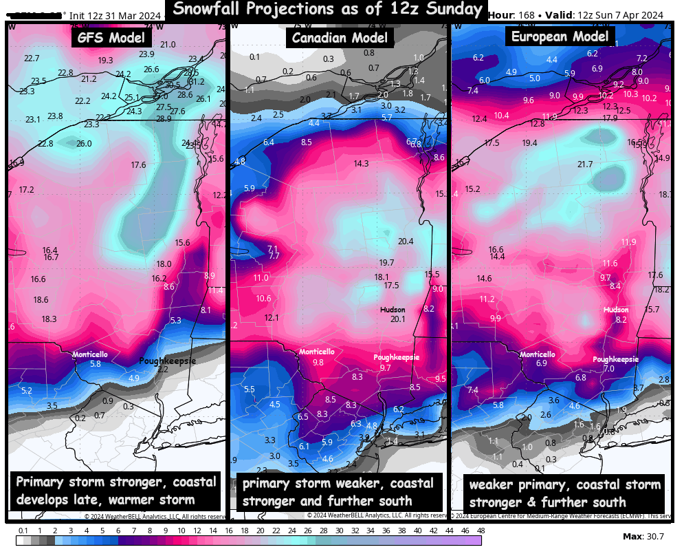
Snow Threat is Gradually diminishing…

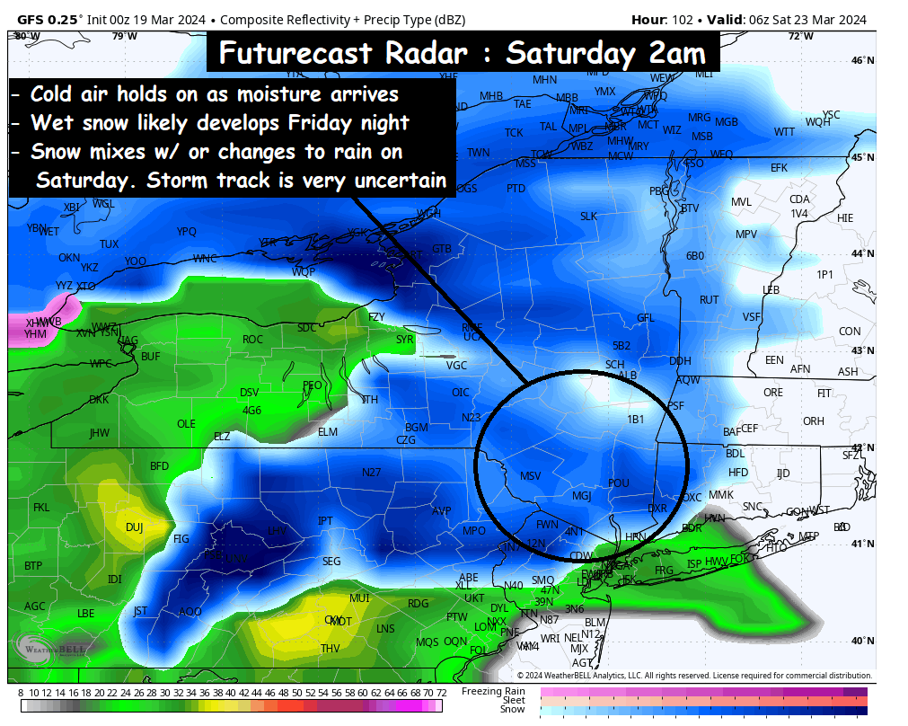
For several days, we have been watching for the potential of a coastal low-pressure system intensifying quickly… and causing the rain to end as a period of heavy, wet snow.

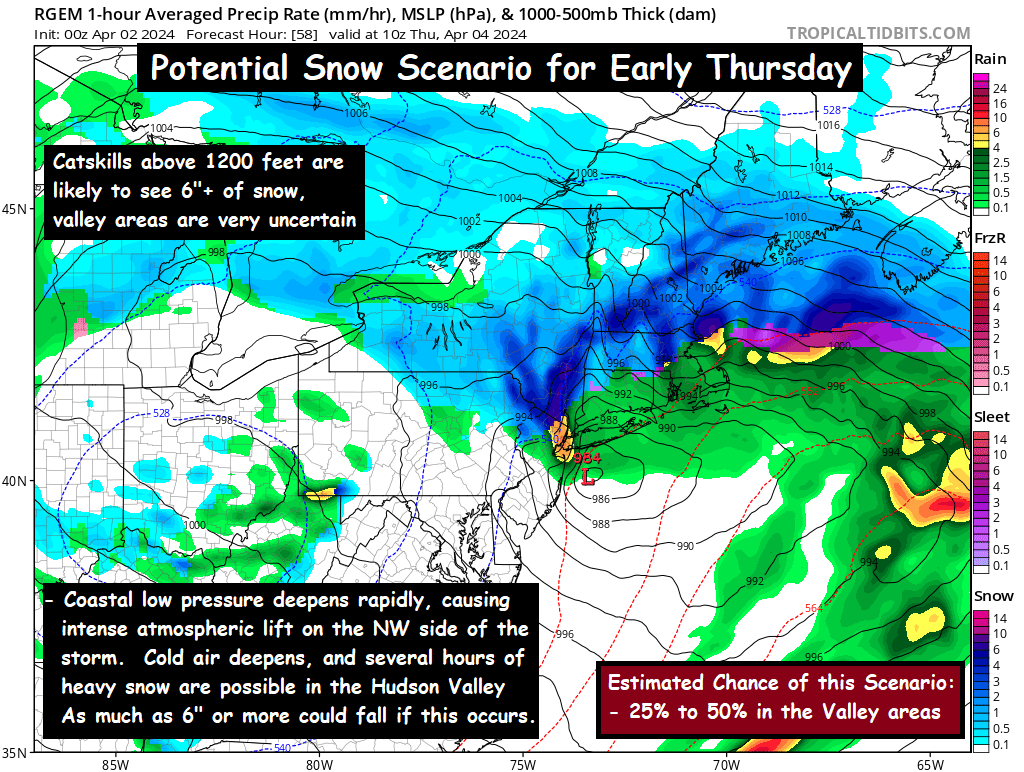
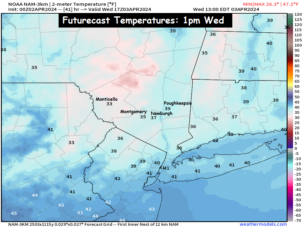
However, as we get closer to the event… we are noticing that temperatures at the mid levels of the atmosphere are just a bit too warm to support snow for many places.  So despite surface temperatures in the mid 30s for many locations Wednesday evening… temperatures 5000 feet up are projected to be several degrees above freezing through midnight Wednesday night.  By that time, most of the precipitation will have pushed east of the Hudson Valley.

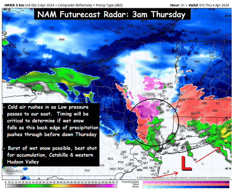
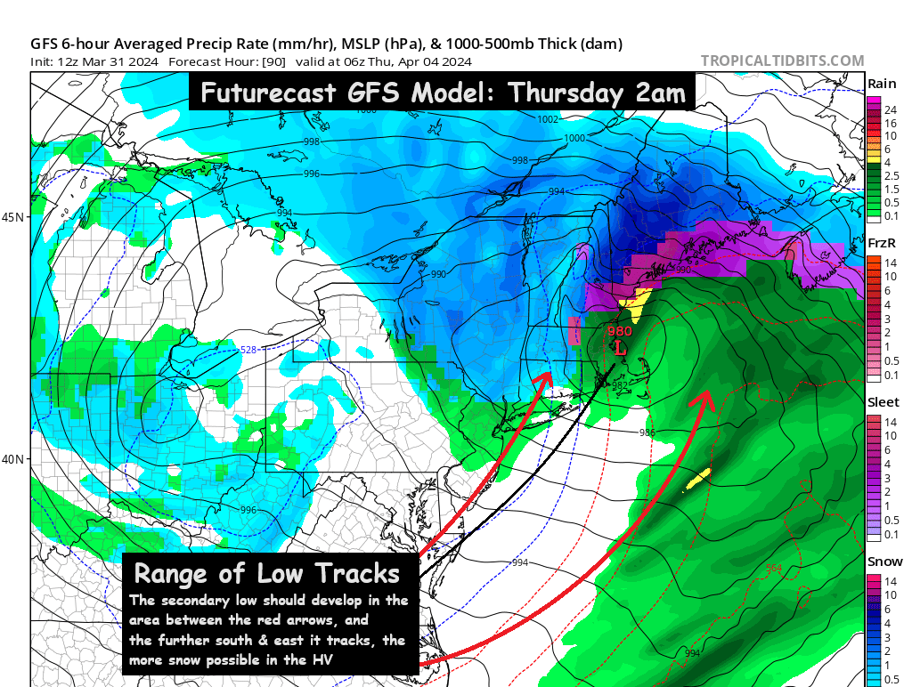
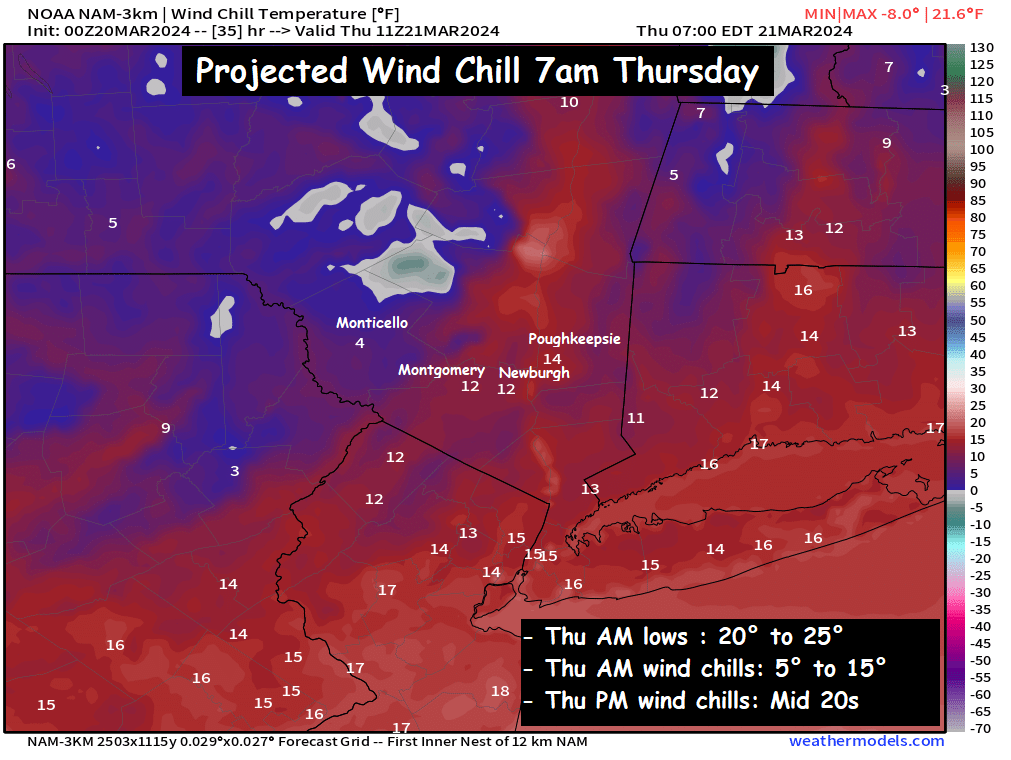
This graphic shows the scenario most likely at this time.  You can see the cold air is struggling to rush into the mid levels by 2 or 3am Thursday across the eastern Hudson Valley.  The most likely outcome is rain mixing with wet snow in the valley before sunrise… with some areas getting a slushy coating to an inch of wet snow on grassy surfaces.  The best chance for accumulation over 1 or 2 inches would be in the Catskills above 1200 feet.

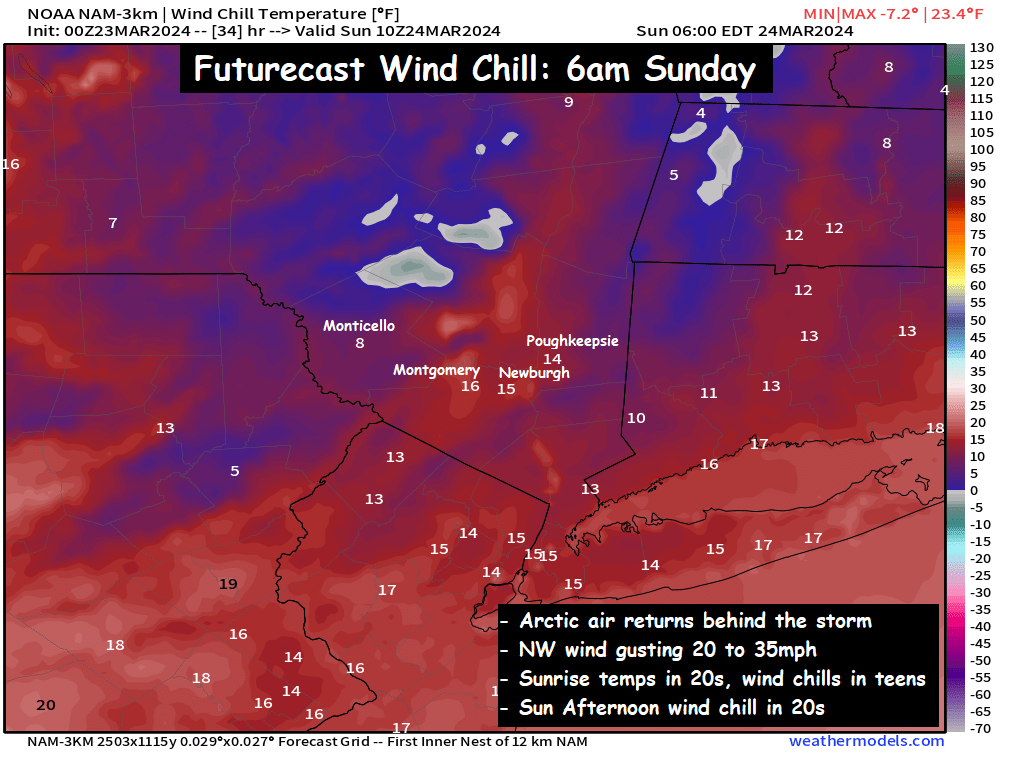
It’s going to be a very tricky situation in terms of the outcome.  The calendar reading April 3rd is a major factor against the idea of snow, so we need a cold invasion of air from Canada to allow it to snow.  While that cold air does arrive Thursday morning… by the time it does, the precipitation has likely exited.  So we’ll monitor the situation as it develops on Wednesday, and if it appears more likely to snow in some areas… we’ll share that information.  Otherwise, it’s probably a safe bet to plan for a sloppy and raw Thursday AM commute, that could feature a few slick spots.  This way you can adapt either way, depending on how the details shake out.

Be sure to check back for more updates later in the day on Wednesday… Have a great Wednesday… bundle up and stay dry!

-Bill

Tuesday Discussion : Rainy Weather… Eyes on Wed Night

After a dry start to the work week, things will turn rainy and raw for our Tuesday.

Rain showers will develop during the morning hours and expand in coverage and intensity during the day.  The morning commute looks rather dry, but that will change by mid morning across the region.

Futurecast Radar : 6am Tuesday – 12am Wednesday

Temperatures in the valley are expected to linger in the low to mid 40s all day.  Make sure you keep a coat and umbrella handy for your Tuesday, as roughly an inch of rain is expected between now and sunrise on Wednesday…

Wednesday looks a lot like Tuesday… with periods of rain expected.  Another inch of rain is expected between 8am Wednesday and 8am Thursday (on top of the 1 inch of rain expected Tuesday into Wed AM).  The big question that becomes interesting on Wednesday… will be just how cold do the temperatures get across the region?  Most of the guidance gives us a cold rain on Wednesday, but afternoon temperatures are likely held down in the 30s!

The key will be with regard to the details.  Some guidance like the HRRR (and even the NAM) has a combination of rain mixing with sleet during the afternoon hours on Wednesday.  Those falling temperatures will mean everything with regard to the details of what kind of weather we see Wednesday night into Thursday.

The HRRR futurecast is aggressive with the southward push of the sleet on Wednesday afternoon and evening… which is an ominous signal for Wednesday night into Thursday.

What is going to happen Wednesday Night – Thursday???

At this time, it truly is a bit of a toss up on how things unfold.  Temperatures are going to be so close to freezing… that it will likely depend on how rapidly the coastal low pressure intensifies Wednesday night.  If the coastal low begins to bomb out and intensify quickly… it could develop an area of heavy precipitation, that with the atmospheric temperature profile so marginal… we could see a burst of 3 to 6 hours of heavy, wet snow across parts of the region between midnight and sunrise on Thursday morning.  It’s also possible that the early April temps are just too warm to support snow, and a wintry mix of slushy snow and rain fall.  The details will continue to be worked out slowly on Tuesday.  No matter what… an ugly week of weather lies ahead.  Check back for updates as we get closer…

-Bill

Monday Morning Discussion: Will it Snow this Week?

April 1st arrives on Monday, and a common ‘April Fools’ joke in weather forecasting is to toss out a forecast for snow.  Fortunately (or unfortunately depending on your point of view), this time the conversation about snow is not a joke.  If the upper air pattern shifts properly over the next several days, we could be in position for some wet snow Wednesday into Thursday.  Let’s go through the setup…

A wave of low pressure will push into the Ohio Valley on Tuesday into Wednesday, and that will spread rain eastward into the Hudson Valley on Tuesday and Wednesday.  Chilly air will linger with temperatures in the upper 30s to low 40s on Tuesday and Wednesday.  Blocking to our north will prevent the storm from progressing eastward, and the low pressure will get trapped somewhere between Ohio and Michigan.  That part of the setup is pretty well understood… the main question being how strong the initial storm gets, and how far north the low pressure moves before stalling.  This is important, because it will determine the details on phase 2 of the storm.

A coastal storm will develop Wednesday night, and track northeastward.  The intensity and track of the initial low pressure system will help determine where the secondary coastal low pressure develops… and how much energy remains for the coastal low pressure to intensify.  This all becomes very important… because if the coastal storm intensifies quickly, and tracks far enough south and east… temperatures over the Hudson Valley could crash Wednesday night and heavy precipitation could fall in the form of snow.

If the coastal low pressure is weaker like the GFS model (above) suggests, the Hudson Valley sees cold rain mix with wet snow Wednesday night into Thursday.  If the coastal low intensifies quickly and tracks further southeast like the Canadian and European models are currently suggesting… the Hudson Valley would see rain on Wednesday change to a heavy wet snow Wednesday night into Thursday.   If the colder solution ends up being correct… accumulations could be quite substantial, especially for early April.


You can see the wide range of snowfall possibilities… from nothing at all, to nearly a foot of snow in some portions of the valley.  We want to emphasize… it is extremely late in the season, and accumulating snow is very hard to come by.  We need multiple factors to come together at the same time.

What do we need?

  1. We need the first piece of the storm to be weaker and further south… this will allow cold air to filter into New England from a Canadian high pressure system.  The first storm being weaker and further south prevents milder air at the mid levels from getting too far north, and sets the stage for favorable conditions when the coastal storm develops…
  2. We need the second storm to be stronger and further south… the rapid intensification of the coastal low pressure will generate dynamic cooling, rapidly rising and cooling the air mass, then the heavy precipitation pulls that colder air down through the atmosphere… cooling the column of air from top to bottom.

If those two things happen, we could very well have a winter storm to contend with on Wednesday evening and Thursday.  Keep in mind… we will have rain across the region Tuesday into Wednesday… but Wednesday night into Thursday is the period that could see wet snow… IF… the conditions unfold properly.  Be sure to check back for more details Monday and Tuesday… as we get closer to the storm unfolding.

-Bill

Thursday Discussion : Unsettled, Damp and Cool

A frontal boundary slowly pushing east has brought clouds and scattered showers to the Hudson Valley. Many areas saw a period of moderate to heavy rain showers late Wednesday afternoon as a result. That boundary will slowly push east, and a low-pressure system will develop in the Southeast US on Wednesday night and move NE early on Thursday. This could spread a period of steady rain into the lower Hudson Valley before sunrise on Thursday.
The map shown depicts rainfall totals by Thursday night, and you can see where the heavier rainfall totals are projected to be. The best chance for periods of rain will be areas south of I-84, as well as areas east of the Hudson River (the southeastern half of the valley). The further north and west you go, the fewer rain showers are expected… and so the lower rainfall totals as well.
 
The recent trend in data has been to push the rain showers on Thursday a bit further to the east… which if correct, will mean less rainfall for all of us on Thursday, and more of a cloudy and damp day instead. We’ll see how it unfolds as the coastal low pressure moves northeast on Thursday. Either way, a damp, cool (mid 40s for highs) and cloudy day is on tap for Thursday.
 
Weekend Preview :
Fri: Mix of clouds & sun, highs in mid to upper 40s
Sat: Partly cloudy, highs upper 40s to low 50s
Sun: Clouds & sun, high in low to mid 50s.
 
Stay Dry on Thursday, Hudson Valley!
-Bill

Monday Discussion : Monday Sunshine fades behind Midweek Clouds

A beautiful start to the work week, at least by mid March standards.
Abundant sunshine and blue skies along with seasonable temperatures in the low to mid 50s will feel quite nice to kick off our week. But a blocking pattern will allow for moisture off the Atlantic Ocean to spread clouds and mid level moisture that could kick off some patchy light showers and drizzle Tuesday afternoon and Wednesday across the Hudson Valley. This will by no means be a washout, but it will keep the skies mostly cloudy Tuesday afternoon and Wednesday. Highs all 3 days should be in the low to mid 50s… with Wednesday being the mildest of the 3.
 
Then as a cold front reaches the coast by Thursday, a low pressure system is likely to develop in the Southeast US along the boundary. That low will push northeast, up the coastline, and could spread rain showers into the Hudson Valley and northeast Thursday afternoon and Friday. The position of the boundary will be key to determining the track of the storm, so we’ll watch it closely. The best chances for rain will be closer to the coast… as much of the guidance keeps the low pressure a bit offshore. But it’s something we’ll need to watch closely through the week. To be clear, this coastal storm would be all rain, except for the Catskills… as temperatures Thursday and Friday are projected to be in the upper 40s to low 50s.
 
We’ll have more discussions on the weather through the week. Have a great start to your week, Hudson Valley!
 
-Bill

Saturday Storm Discussion: Cold, Soaking Rain

A cold, raw day is in store for the Hudson Valley on Saturday.  Rain will develop before sunrise, and fall steadily throughout the day.  By the time the storm exits late on Saturday, a general 2 to 2.5 inches of rain are possible across the region.

As the rain develops between 1am and 4am… temperatures are projected to be in the low to mid 30s.  It’s possible that some pockets of freezing rain and sleet could develop in that timeframe.  But by sunrise, we do expect all precipitation to change over to a cold, plain rain.

Temperatures on Saturday will likely hold in the mid 30s to low 40s around the region, making for a very raw and nasty day across the region.  The periods of rain will become steadier and heavier as we go through the day.  By early afternoon, most of the region should be experiencing a steady moderate to heavy rain.

The rain should taper off from SW to NE between 4pm and 8pm, as the low pressure passes by to our SE.  Once the low pressure passes by, cold air will quickly return to the valley, and temperatures will tumble back into the 20s and low 30s by midnight.  Some areas of black ice are possible, depending on how much time passes between the end of the rain, and the air temps falling below freezing.  By Sunday morning, it will feel like winter once again…

Temperatures will be in the low to mid 20s on Sunday morning… but NW winds gusting over 20mph at times should make for “real feel” wind chills in the teens and even some single digits.  Make sure you’re ready for a quick return to winter’s chill behind this storm system.

We’ll have updates on the storm through the day on Saturday…

-Bill

Thursday’s Discussion : A Return to the Middle of Winter

The first half of March across the Hudson Valley was extremely warm. We were roughly 10 degrees above average through mid month. But with the passage of an arctic cold front on Wednesday, just like that… winter has returned with a vengeance.
Be sure to bundle up those kiddos before you send them on their way out to the school bus stop on Thursday. Because NW winds gusting 20mph to 30mph will combine with temperatures in the mid 20s early Thursday morning to give us wind chills in the single digits and teens for the AM commute. The winds continue to gust through the day, keeping the chill locked into the region through the afternoon. Afternoon highs in the mid 30s will never feel that warm, thanks to persistent NW gusts. Wind chills at the warmest part of the day are expected to be in the mid 20s… making it feel like the middle of winter, just in time for the 2nd day of spring.
Conditions will moderate a bit on Friday, with winds shifting out of the south. Highs on Friday should reach into the low and mid 40s, which is still below average for this time of year. Then our eyes turn to Friday night and Saturday, as two pieces of energy meet up along the east coast. A short wave approaches from the west, while a coastal low pressure develops along the Carolinas by sunrise on Saturday. This will cause rain to develop and overspread the entire region early in the morning on Saturday. The rain then continues through the day on Saturday, and the afternoon looks very soggy, with periods of rain and temperatures in the low to mid 40s. Unfortunately, our snow lovers will be left out in the cold rain once again… a common theme this winter.
 
We’ll have more updates on the weekend’s weather as we get closer. Bundle up and have a great Thursday.
-Bill

Wednesday Discussion : Arctic Front Approaches

Colder air has pushed into the Hudson Valley, but some even colder air is on the way.  We’ll see a mix of clouds and sunshine on Wednesday, with highs in the low to mid 40s.  SW winds gusting 10 to 20mph during the day will give us wind chills in the 30s and low 40s.

But this is out ahead of an approaching arctic cold front.  The front should reach the Hudson Valley between 3pm and 7pm, and it will bring some scattered valley rain showers, along with mountain snow showers.  But as the arctic front passes, snow squalls could reach even into the valley areas near sunset.

This could make for some tricky PM commuting on Wednesday.  Something we’ll try to monitor through the day.  But you should expect some scattered rain and wet snow showers late Wednesday afternoon and evening… followed by rapidly falling temperatures and frigid wind chills.  Low temperatures Wednesday night should fall into the low and mid 20s… with wind chills in the low to mid teens.  Make sure you prepare accordingly.

Spring may have started on Tuesday… but it’s going to feel very much like winter for the next few days.

Tuesday Discussion : Spring Arrives & Winter Returns

Spring officially arrives at 11:06pm on Tuesday March 19th.  So naturally, winter will return on Tuesday.

A frontal boundary will swing through the northeast, as a deep trough dives southward from Canada.  This will bring a batch of very cold air south from Canada, and into the Northeast.  This will cause gusty winds out of the NW at 20 to 30 mph Tuesday afternoon, and by late in the day, scattered flurries and wet snow showers are possible (mixed with rain in the valley areas)

In addition to the blustery conditions generating lake effect wet snow showers… the winds will cause the cold air mass to feel sharply colder.  Temps on Tuesday afternoon are expected to reach the upper 30s and low 40s in the valley areas (mid 30s in Catskills).  When you factor in the NW winds gusting over 20mph at times… the ‘real feel’ wind chills will dip into the 20s and low 30s!!

It was only a few days ago when high temperatures in the Hudson Valley were pushing 70°, so this will feel like a bit of a shock to the system.  Wednesday looks cold as well, with afternoon highs in the low to mid 40s, before a reinforcing shot of arctic air dives into the Northeast on Thursday.  That will result in highs in the low to mid 30s Thursday afternoon… with wind chills in the 20s during the afternoon.

All of this sets the stage for a potential winter weather event for Friday night and Saturday.

Another trough dives south from Canada on Friday… and at the same time a coastal low pressure system develops in the southeast.  The details of how this system develops are still very unclear.  At this time, it looks like a period of wet snow is likely to develop Friday night into Saturday.  The main question that needs to be answered, is what happens on Saturday.  Most guidance suggests that milder air moves in on Saturday and turns the wet snow into a cold rain.  A couple inches of wet snow appear possible at this time… before a changeover to a soaking rain Saturday afternoon.  Some guidance brings a coastal low pressure up the coast along with a soaking rain for the I-95 corridor, but other models keep the low pressure offshore.  So, we’ll need to watch this closely over the next few days.

As far as Tuesday is concerned… let’s prepare for the arrival of Spring, with a return of a wintry air mass.

Sunday Turns Breezy, Continued Mild

A cold front will swing through the region Sunday morning, but it won’t cause temps to plummet. Instead, we’ll see clouds mixing with breaks of sunshine, and highs in the mid to upper 50s in the valley (upper 40s in the Catskills). When the front passes early in the morning, a few scattered showers are possible, along with a few mountain snow flurries. Overnight temperatures will gradually fall Sunday night into Monday… getting near the freezing mark by Sunrise Monday.
 
From there, the much colder air moves in Tuesday, with highs near 40° expected, and wind chills in the 20s and 30s. A much colder week coming up, than what we just experienced. Have a great Sunday!!