April 1st arrives on Monday, and a common ‘April Fools’ joke in weather forecasting is to toss out a forecast for snow. Fortunately (or unfortunately depending on your point of view), this time the conversation about snow is not a joke. If the upper air pattern shifts properly over the next several days, we could be in position for some wet snow Wednesday into Thursday. Let’s go through the setup…
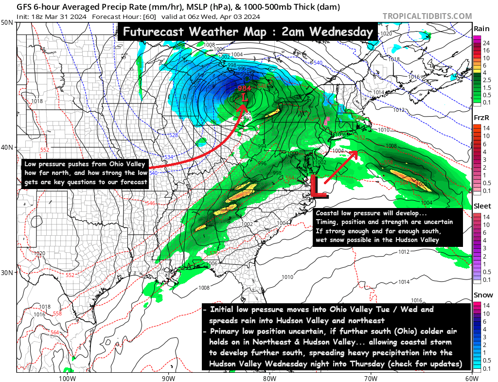
A wave of low pressure will push into the Ohio Valley on Tuesday into Wednesday, and that will spread rain eastward into the Hudson Valley on Tuesday and Wednesday. Chilly air will linger with temperatures in the upper 30s to low 40s on Tuesday and Wednesday. Blocking to our north will prevent the storm from progressing eastward, and the low pressure will get trapped somewhere between Ohio and Michigan. That part of the setup is pretty well understood… the main question being how strong the initial storm gets, and how far north the low pressure moves before stalling. This is important, because it will determine the details on phase 2 of the storm.
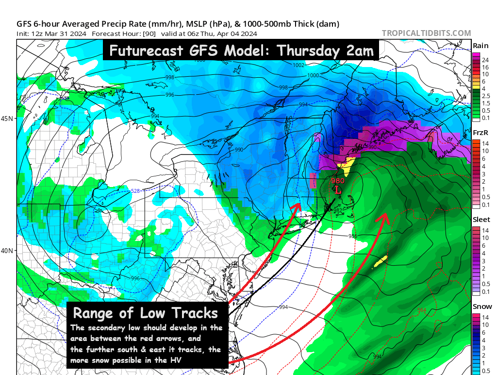
A coastal storm will develop Wednesday night, and track northeastward. The intensity and track of the initial low pressure system will help determine where the secondary coastal low pressure develops… and how much energy remains for the coastal low pressure to intensify. This all becomes very important… because if the coastal storm intensifies quickly, and tracks far enough south and east… temperatures over the Hudson Valley could crash Wednesday night and heavy precipitation could fall in the form of snow.
If the coastal low pressure is weaker like the GFS model (above) suggests, the Hudson Valley sees cold rain mix with wet snow Wednesday night into Thursday. If the coastal low intensifies quickly and tracks further southeast like the Canadian and European models are currently suggesting… the Hudson Valley would see rain on Wednesday change to a heavy wet snow Wednesday night into Thursday. If the colder solution ends up being correct… accumulations could be quite substantial, especially for early April.
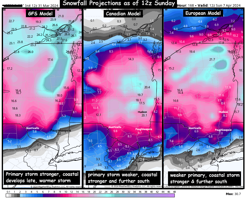
You can see the wide range of snowfall possibilities… from nothing at all, to nearly a foot of snow in some portions of the valley. We want to emphasize… it is extremely late in the season, and accumulating snow is very hard to come by. We need multiple factors to come together at the same time.
What do we need?
- We need the first piece of the storm to be weaker and further south… this will allow cold air to filter into New England from a Canadian high pressure system. The first storm being weaker and further south prevents milder air at the mid levels from getting too far north, and sets the stage for favorable conditions when the coastal storm develops…
- We need the second storm to be stronger and further south… the rapid intensification of the coastal low pressure will generate dynamic cooling, rapidly rising and cooling the air mass, then the heavy precipitation pulls that colder air down through the atmosphere… cooling the column of air from top to bottom.
If those two things happen, we could very well have a winter storm to contend with on Wednesday evening and Thursday. Keep in mind… we will have rain across the region Tuesday into Wednesday… but Wednesday night into Thursday is the period that could see wet snow… IF… the conditions unfold properly. Be sure to check back for more details Monday and Tuesday… as we get closer to the storm unfolding.
-Bill