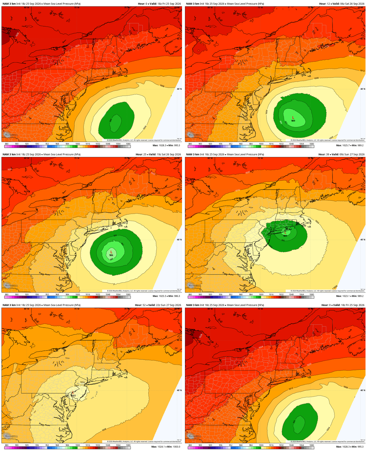
The nor’easter we’ve been tracking is now developing offshore, with surface pressure around 996mb this afternoon and additional strengthening expected tonight as it moves north.
The overall forecast has become clearer, but there are still important timing differences across the Hudson Valley.
The biggest change for us is that the storm has trended a little slower and a little farther south/west. That delays the meaningful rain farther inland and keeps the sharp western edge of the rain shield directly across our region.
FRIDAY EVENING / TONIGHT
Expect increasing clouds and a steadily strengthening north/northeast wind.
Most of the Hudson Valley remains relatively quiet early this evening, while rain continues expanding northwest from the NYC/Long Island area.
Wind gusts of 20–30 MPH will become increasingly common, especially south and east.
SATURDAY
This is still the toughest part of the forecast.
The newest guidance supports a mostly dry or only intermittently damp start Saturday for a good portion of the Hudson Valley, especially farther north and west.
Rain gradually expands northwest during the day, but the exact timing remains highly dependent on location.
If you’re south and east — especially near I-84, southern Dutchess, southern Ulster, Putnam and Orange County — the chance for rain arriving earlier is much greater.
Farther north and west, there may still be a decent chunk of Saturday to work with before steadier rain arrives.
This remains similar to trying to pinpoint the heavy snow band in a winter nor’easter: the overall storm track can be correct, but a 30–50 mile difference in where the precipitation shield sets up can completely change local impacts.
SATURDAY NIGHT INTO SUNDAY
This is when confidence increases in more widespread rain across the Hudson Valley.
The storm becomes vertically stacked, slows down, then begins to drift or retrograde back toward the west/southwest.
That unusual motion allows Atlantic moisture to wrap farther inland.
Periods of steady light to moderate rain are increasingly likely Saturday night into Sunday, especially south and east of Albany.
RAINFALL
The highest totals remain favored across the Mid-Hudson Valley and points southeast.
Current expectations:
• Mid-Hudson Valley / eastern Catskills / I-84 corridor: generally 1–2 inches, locally higher
• NYC / Long Island: substantially heavier, now generally 3-6 inches over the full event
There remains a low-end possibility for localized totals approaching 3 inches near I-84 if persistent bands rotate through.
Despite those totals, widespread flash flooding is not expected because the rainfall occurs over a long period and conditions have been relatively dry.
WIND
The strongest winds will occur Friday night through Saturday night.
For most of the Hudson Valley:
• Gusts generally 25–40 MPH
• 35–40 MPH gusts become more likely across the Mid-Hudson Valley, southern Catskills and exposed terrain
• 40–50 MPH gusts remain most favored farther southeast into NW Connecticut and closer to the coast
There is a much stronger wind field several thousand feet above us, but forecast soundings continue to show a deep stable layer/inversion.
That should prevent most of those stronger winds from efficiently mixing to the ground.
So while some model maps look aggressive, widespread 50–60 MPH gusts across the Hudson Valley are still not the expectation.
The bigger concern is duration.
Fully leafed trees + wet ground + many hours of 30–40 MPH gusts can still produce scattered limbs, isolated trees down and some power outages.
COASTAL FLOODING — CONCERN INCREASING
This has become a more significant part of the storm.
Saturday into Sunday now looks like the peak coastal-flood period, coinciding with the full moon and the highest astronomical tides.
Widespread moderate to locally major coastal flooding is now expected across portions of Long Island and the lower NYC boroughs.
Minor to locally moderate flooding is expected along parts of the lower Hudson and western Long Island Sound.
Closer to home, minor tidal flooding is expected along the Hudson near Poughkeepsie Saturday.
Large surf, beach erosion and dangerous coastal conditions will continue through the weekend.
BOTTOM LINE
Friday evening: Increasing clouds and wind; rain still mainly southeast
Saturday morning: Some areas may still salvage a decent portion of the day
Saturday afternoon/evening: Rain expands northwest, especially across the Mid-Hudson Valley
Saturday night–Sunday: Highest confidence period for widespread rain
Wind: Long-duration 25–40 MPH gust regime inland, stronger southeast/coast
Flooding: Limited inland concern, much greater concern along the coast
Sunday night–Monday: Storm slowly weakens but may continue to spin nearby before finally departing Tuesday
The storm itself is no longer the question.
For the Hudson Valley, the remaining challenge is exactly how far northwest the heavier rain shield gets — and how quickly it gets there.
Newest NAM below is a northern outlier on its track and strength, EURO and GFS remain further south and weaker. We will continue to monitor the latest data and update as needed.