Sunday Discussion : Blustery and Chilly

The storm system from Saturday has exited the region.  That will allow sunshine  and blue skies to return to the region.  For Sunday, expect clouds to mix with sunshine.  Northwest winds will be gusting up to 15 to 25mph, making afternoon highs in the mid 40s… feel more like the mid 30s across parts of the valley.

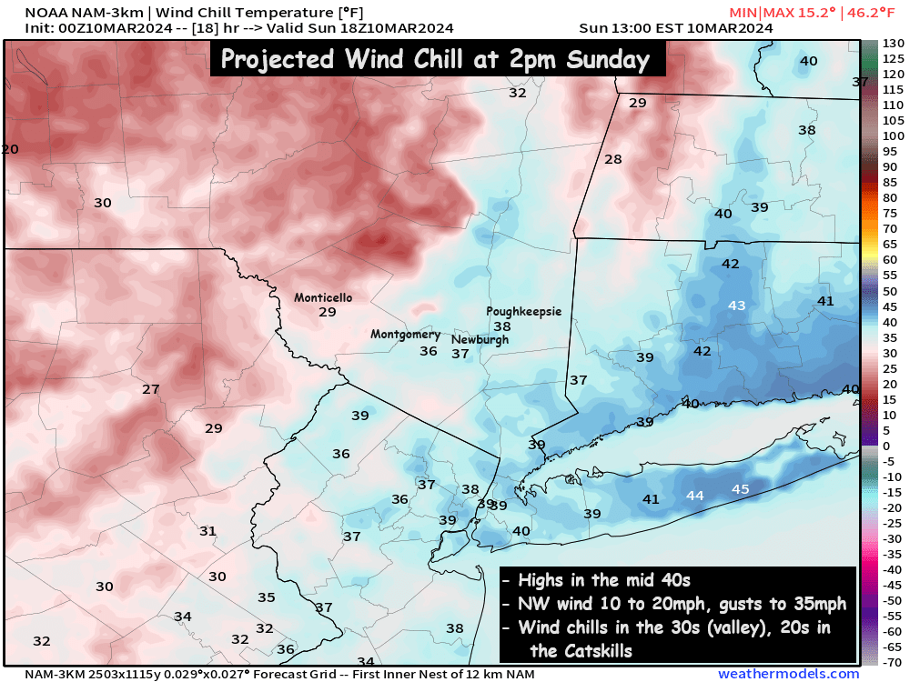
The chill intensifies as the night goes on Sunday night.  The NW winds gusting over 30mph at times, combined with temperatures falling into the upper 20s and low 30s.

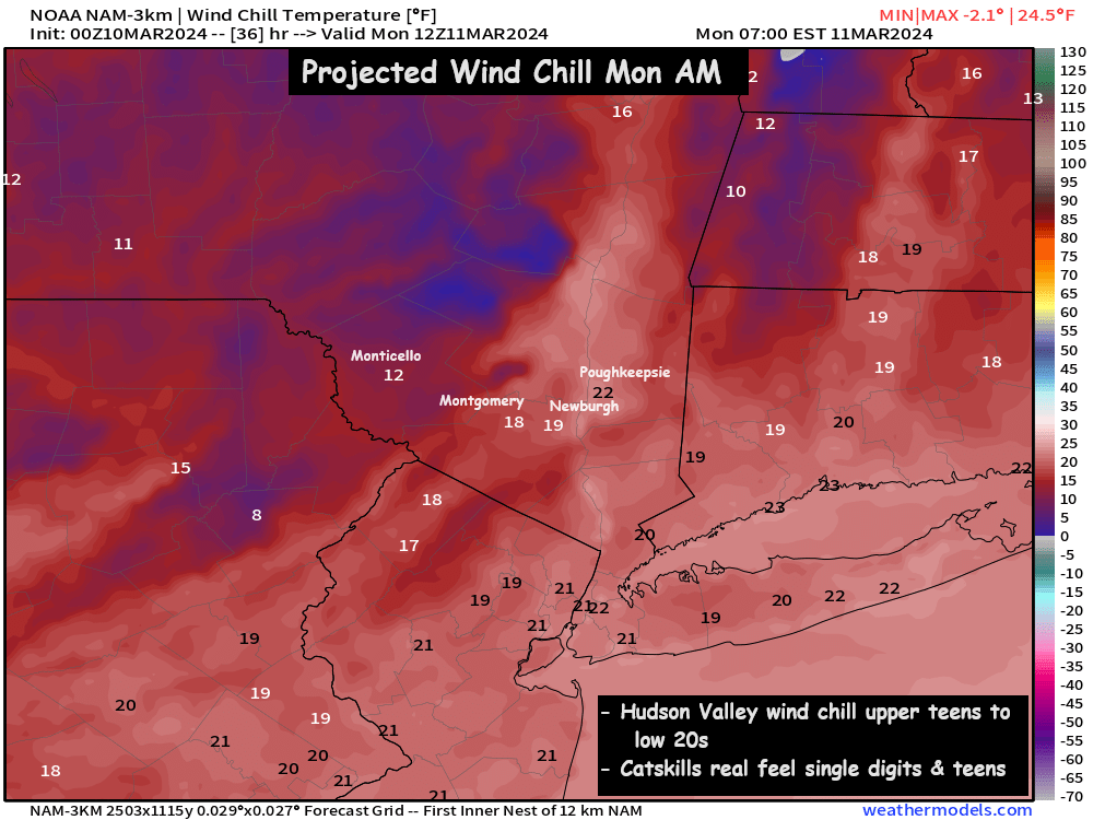
This will make for a bitter cold start to the work week and school on Monday morning.  Temps recently have been very mild (roughly 20 degrees above average)… so this chill will feel even colder than it is.  With Monday morning wind chills in the teens and low 20s across the valley… and single digits and teens in the Catskills.

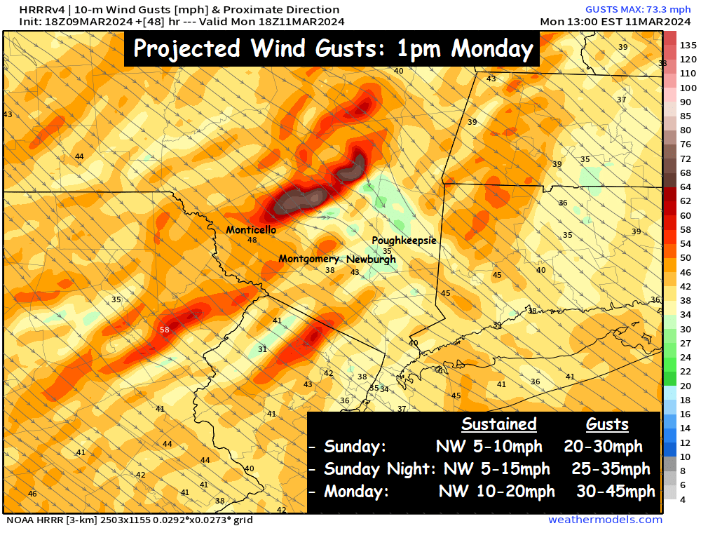
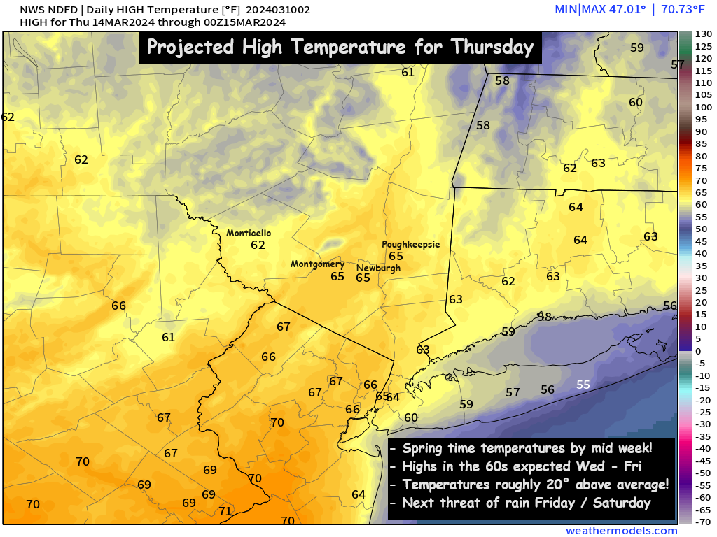
The chill extends into Monday afternoon… with the wind gusts peaking at 25 to 45mph… and locally 55mph in the Catskills.  This will ensure that afternoon wind chills on Monday afternoon don’t get much above freezing.  (despite temperatures in the low to mid 40s).  But big changes are on the way… with southwest winds returning on Tuesday.  This will warm conditions quickly across the Hudson Valley.  By mid week… we could see highs in the low to mid 60s across the Hudson Valley (roughly 20 degrees above average)

A taste of spring is on the way for the Hudson Valley by the middle of this week.  Hopefully some of you will be able to get out and enjoy it!

-Bill


Saturday 5:30pm Storm Update : Flood Watch in Effect

Current Radar as of 5pm Saturday

Rain is pushing through the valley, and areas of light to moderate rain are falling as of sunset on Saturday.  Some wet snow is mixing in across the Catskills, with temperatures in the mid 30s.  2 to 5 inches of wet snow are possible are possible above 1500 feet in the Catskills.  Even there, the wet snow should change to rain as the mid level temperatures warm above freezing.

The Next 6 Hours…

A gap in the precipitation due to some dry air, is pushing NE into northwest NJ, NE PA and soon to be the Lower Hudson Valley.  This will likely cause rainfall to taper to light rain showers and drizzle between 5:30 and 7:30pm across the region.  But we do anticipate the radar to fill back in behind the area of dry air… and periods of moderate to heavy rain should re-develop between 7 and 9pm across the Hudson Valley.  Then moderate to heavy rain is expected to until midnight or so.

The rain pushes NE rapidly around midnight, and shortly after midnight the rain is projected to taper off…

Futurecast Radar : 2am Sunday

The rain should taper off between 12am and 3am from SW to NE.  From there we could see a few scattered rain showers or wet snow showers… as temperatures fall into the mid and upper 30s overnight.  Total Rainfall still remains projected around 1 inch on average, with some locally higher amounts possible.  That’s why the region is under a Flood Watch.

Then on Sunday we’ll see winds increase out of the northwest… giving us a blustery and cold Sunday afternoon into Monday.

Sunday afternoon wind gusts at 20 to 30mph, combining with temps in the low to mid 40s, to generate wind chills in the 30s.  Sunday night, temps fall into the upper 20s and low 30s… resulting in wind chills in the in the teens and 20s.  Monday looks blustery and cold, with highs in the upper 30s to low 40s… and wind chills in the 20s.  More updates as we move through the evening…


Storm Discussion : Saturday Afternoon/Night Rainfall

Another storm system quickly marching across the country from west to east, will spread rainfall across the Hudson Valley Saturday afternoon.

Timing:
– 12pm to 4pm : rain develops from west to east (wet snow possible above 1500 feet)
– 6pm to 12am : heaviest rain expected
– 12am to 6am : rain ends from SW to NE

Impacts:
– Between 0.5 and 1.5 inches of rain expected
– Catskills could see wet snow accumulation of 3 to 6 inches (especially above 1500 feet)

Rain will develop Saturday afternoon, as early as 12pm near the NY/PA border, and as late as 3 or 4pm near the NY/CT border.  Temperatures at the onset of precipitation are expected to be in the mid to upper 30s across the valley, Rain could mix with sleet and wet snow at the onset, especially in the higher elevations.  The Catskills, and areas above 1500 feet could stay wet snow for several hours and see several inches of accumulation with temperatures in the low to mid 30s.

The heaviest rain likely falls between 6pm and 12am, as the area of low pressure passes very closely to NYC shortly after midnight.  The precipitation should taper off before sunrise on Sunday.  By the time it does, around 1 inch of rain is common… with some areas slightly less, and some locations up to 1.5 inches.  This could cause some stream and river flooding around the region, especially in the Catskills.  With regard to the Catskills… some guidance suggests that snowfall accumulations of several inches are possible.  But you can clearly see that the valley areas are almost entirely rain… with temperatures expected to be in the upper 30s across most valley areas.

We’ll have to watch things closely as we go through the day on Saturday.  Expect more updates as we get closer.

-Bill

Thursday’s Weather : Drying Out Slowly

After a fully saturated Wednesday across the valley, with rainfall amounts between 1 and 2 inches on average… We’ll see the precipitation exit the Hudson Valley around sunrise on Thursday.  The steady rain should taper off before sunrise… but a few leftover showers and areas of drizzle are possible through the Thursday AM commute.  By mid-morning, the majority of the area should be mainly cloudy… but dry.  Clouds will linger through the day… with a few peeks of sun possible before sunset.  Afternoon highs on Thursday should be in the upper 40s to low 50s.

Friday looks to see some breaks of sunshine to close out the work week.  The ridge in the eastern US continues to hold, which means we’ll have a mild day on Friday.  Currently we expect a mix of clouds and sunshine… and highs in the mid 50s.

Next Storm System : Saturday Night / Sunday (mainly rain)

Clouds advance back into the region on Saturday ahead of our next storm system.

Rain is likely to develop by late afternoon or early evening on Saturday.  An upper level low pressure will drop in from Canada, and could bring enough cold air to result in high elevation wet snow, but this variable needs to be monitored in the next 2 days.  Periods of rain are then likely to fall through Saturday night, before tapering off Sunday morning.  The track and strength of the upper level low need to be monitored… but in general, around 1 inch of rain (precipitation) is expected by Sunday afternoon.

Temperatures on Sunday are likely to be in the upper 30s to low 40s… along with the roughly 3/4 to 1 inch of rainfall.  We’ll be monitoring this storm system closely in the next day or two.  Check back for more details in the coming days… otherwise, have a great Thursday!

Areas of Dense Fog followed by Heavy Rain

Our next coastal low will track NE into the region this afternoon and overnight, our ahead of it we have cloudy skies and areas of dense fog. Weather will start to go down hill by later this afternoon with period of heavy rain overnight.

Tracking the rain- areas of showers break out between noon and 2pm, widespread moderate rain overtakes the entire region between 5-7pm. Rain becomes heavy at times between 7pm and 2am, heavy rain continues to track north overnight with waves of heavy rainfall pushing into the region from the south. Steady rainfall lingers into the morning Thursday before ending between 8-10am, with only scattered showers through noontime, especially NE parts of the region.

Here’s a look at the simulated radar for overnight, showing widespread moderate to heavy rainfall across the region.

All set and done rainfall amounts of 1-3” will be likely with the highest amounts across the southern facing slopes of higher terrain.  Flood watches remain in effect for Westchester, Rockland and Putnam counties where 2”+ of rainfall is most likely to occur. Everyone stay dry, careful driving this morning with the dense fog.

Rainy Saturday

Precipitation associated with our next system will move into the region from west to east early tomorrow morning between 3am and daybreak. Initially some of this precip may start off as a period of wet snow across the Catskills, this will be limited to elevations above 1500’ with the rain/snow elevation line rising by daybreak. Showers and periods of steady rain will persist through much of the day before tapering off from west to east between 6-10PM.

Here’s a look at projected rainfall amounts and what the radar may look like tomorrow before daybreak. Rainfall amounts will be heaviest across SW parts of the region where .40-.60” may fall and lightest across NE parts of the region where rain may be a bit slower to start, where .20-.30” may fall.

Now for the silver lining, once we get through a dismal Saturday we look to pull out a decent Sunday with partly sunny skies and temps pushing into the upper 50’s with the exception of the Catskills where clouds and cooler temps may be a bit more stubborn. Here’s a look at projected temps for Sunday.


Warm Up Inbound

Seasonable Sunday, but Warm Air on the Way…

We’ll have sunshine to start our Sunday in the Hudson Valley, but we’ll watch as clouds increase through the afternoon hours. Highs on Sunday should be in the upper 30s to low 40s. Then temps will fall near freezing Sunday night… and a very weak frontal boundary will drift through the region. It could touch off a few scattered rain or wet snow showers around the Monday AM commute. Even a few areas of freezing drizzle are possible, so we have some minor concerns about icy spots Monday morning. We’ll monitor the threat through the day on Sunday and provide an update Sunday night, so you can prepare for the Monday AM commute.

However, behind the warm front on Monday, temperatures will jump quickly… pushing 50° Monday afternoon. Then an early taste of spring on Tuesday and Wednesday, with temps in the mid to upper 50s expected… thanks to the upper level ridge returning. Some scattered showers are possible on Wednesday and Wednesday night… possibly ending as a bit of snow before we have a cold end to the work week.

A possible slick start to the work week, followed by milder temps. We’ll have updates along the way. Also, the website may be down for a bit on Sunday as we continue to make upgrades. Have a great Sunday!

Bill