Locally Significant Rainfall Possible on Tuesday

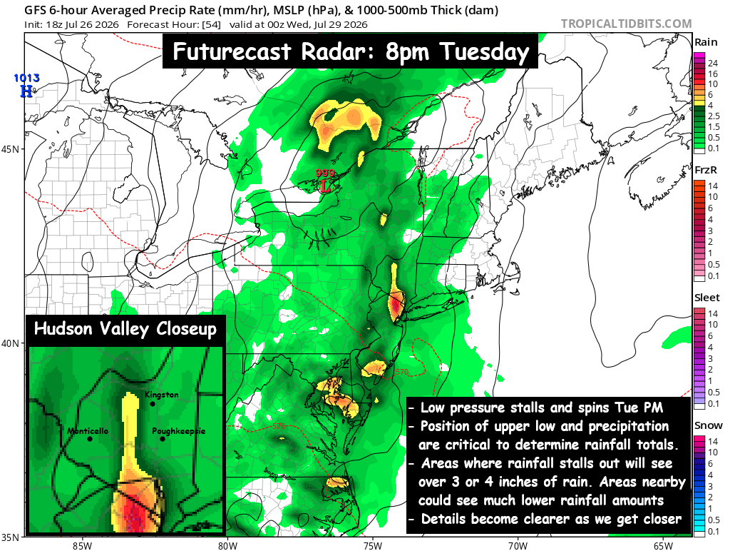
Low pressure will move toward the Northeast on Tuesday, and spread rainfall out ahead of it. The upper level trough will capture the system and cause it to stall out for several hours Tuesday night into Wednesday. This is expected to cause the rainfall to slow down as well, and the Hudson Valley could see several hours of locally heavy downpours.
 
Rainfall totals between 2 and 4 inches are possible, with locally higher totals possible where the heavy downpours persist the longest (Image #1 above). Some guidance suggests upwards of 5 or 6 inches in a few isolated areas. The biggest challenge continues to be exactly where this area of heaviest rainfall will be. As the low pressure slows down… the rain should begin to pivot over the same areas, and that could result in excessive rainfall.
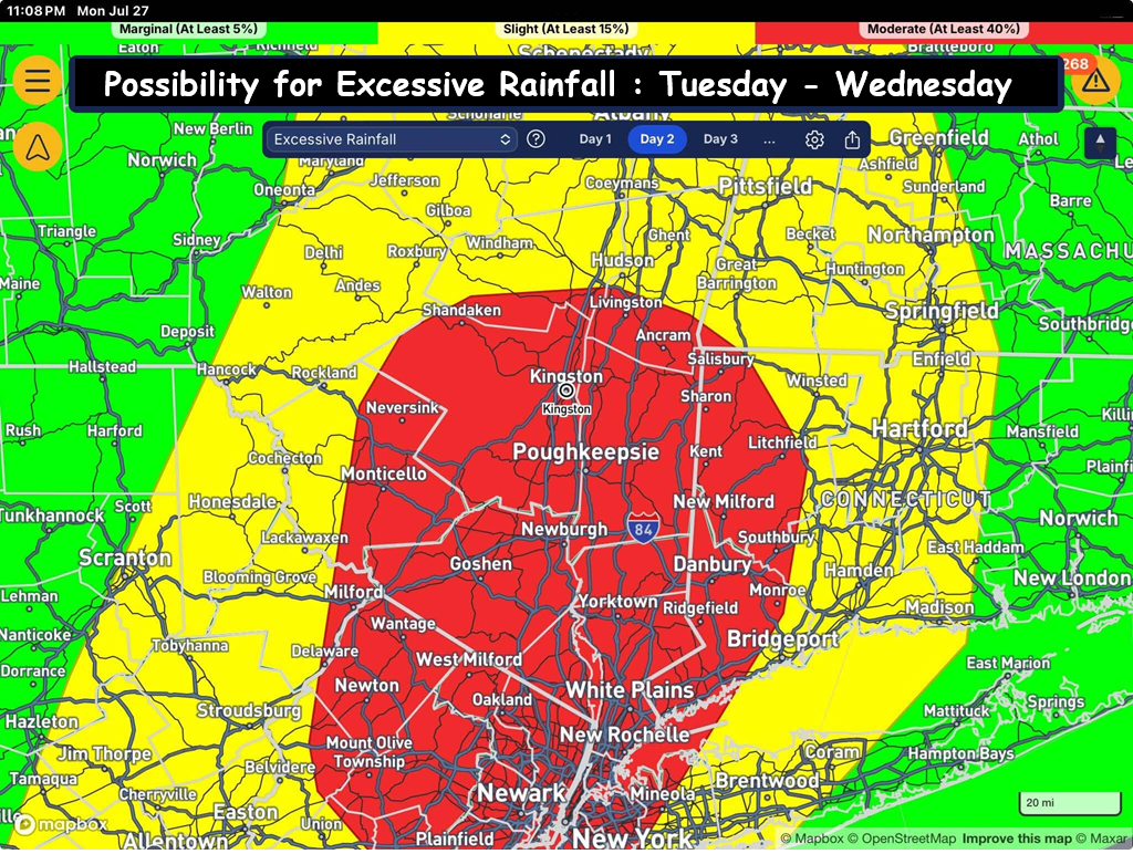
(Image #2) shows where the highest chances of excessive rainfall are… with the best chances being over portions of the Hudson Valley (roughly 40%). But there is other guidance that suggests the heaviest rainfall could be over parts of CT and MA. For this reason, a Flood Watch is in effect for the entire region.
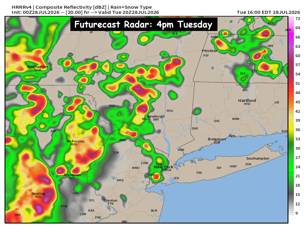
(Image #3) shows the heavier scattered showers, T-Storms & downpours develop between 2pm and 6pm. So as the afternoon continues, conditions are expected to deteriorate. The bands of heavier rain are expected to pivot between 6pm Tuesday and 6am Wednesday. During that time, is when the highest risk for excessive rainfall and flooding will occur. We’ll have to monitor the situation closely as it develops on Tuesday.
 
For additional thoughts on this system, you can also refer to our post from Sunday night: https://www.facebook.com/share/p/198v9grEGK/
 
A complex system will impact our area on Tuesday. Grab the rain gear and keep an eye out for updates on Tuesday.
The Week Ahead – Upper Low Stalls & Brings Soaking Rain

An upper level trough will dig into the Northeast on Tuesday, and cause a surface low pressure to stall out over parts of the Northeast Tuesday into Wednesday, and the result could be a significant rainfall for parts of the region.
– Scattered rain showers develop Tuesday afternoon
– Bands of rain and areas of downpours likely stall out Tuesday night.
– Some areas could see several hours of heavy rain into Wed AM
– Low pressure loops, and pulls away Wednesday night
– Wide range of rainfall possible: 1″ to 4″+
 
A tricky system will impact the region on Tuesday… with characteristics more typical of an autumn storm. The jet stream will buckle just a bit over the northeast, allowing an upper level low pressure to capture a weak surface low pressure late on Tuesday… and cause it to nearly stall out for several hours, before finally moving away Wednesday evening.
 
Areas of scattered showers and even a few thunderstorms likely develop Tuesday afternoon (especially in the western HV). Those rain showers and embedded downpours will slow down, and should stall for several hours, before slowly pivoting around… and pulling to the east. The big questions are:
– exactly where does this low pressure track?
– where does it stall out?
– and how quickly does it pull away?
Where the showers and downpours stall or slow down… heavy rainfall totals are possible. Some guidance suggests that over 4″ or 5″ of rain could fall in some locations… while areas just outside of those stalled bands of rain, could see 1″ or possibly less.
– Some guidance says this will happen just to our west, putting the highest rainfall totals over PA and central NY.
– Some guidance says this will happen just to our south, dropping over 5″ in NJ, while areas from I-84 on north see only an inch.
– Much of the guidance says this will happen over parts of our area, the question is “which part of the region?”
 
The current forecast is for 2″ to 4″ over much of the Hudson Valley, with some localized areas possibly breaking 5″. The storm should gradually pull east Wednesday night, into Thursday morning. Conditions should begin to dry out Thursday, hopefully with some breaks of sun returning. But these upper level low pressure systems can be tricky to forecast, so we’ll have to wait and see how things unfold, and share updates about how quickly we expect conditions to improve.
 
We’ll have to watch this closely to see how the details unfold. We’ll have more updates as we get closer.

Tuesday Weather Outlook : Showers, Downpours & Potential Severe Storms

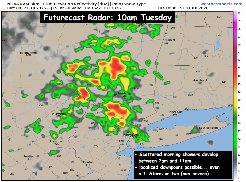
– Scattered showers develop 7am – 10am… localized downpours
– Early PM Scattered showers & Storms… (possibly taper off?)
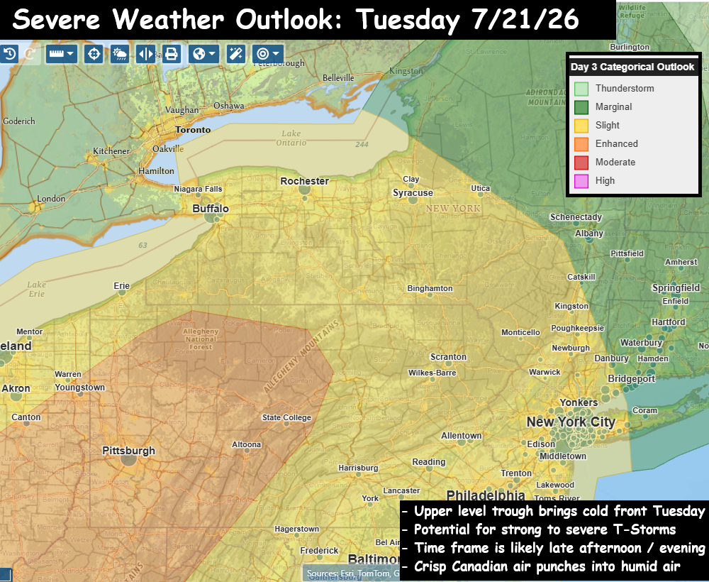
– Potential for Severe T-Storms (highest 5pm to 9pm)
 
Two gorgeous days around the region between Sunday and Monday… and now we’ll watch as the winds shift out of the south for Tuesday and allow moisture and humidity to return to the Hudson Valley. Scattered showers are expected to develop between early and mid morning on Tuesday… and some of the showers could produce locally heavy downpours. The scattered showers & T-Storms during the late morning and early afternoon are not expected to be severe… but we could see some localized heavy rainfall totals from those storm cells.
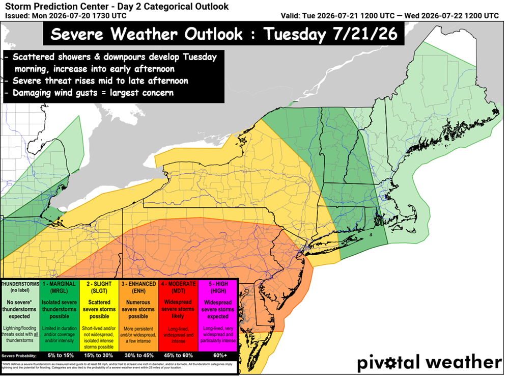
The severe threat comes later in the day, with the approach of another cold front. Mild and humid air will be in place Tuesday… with highs in the mid to upper 70s, and dew points in the low to mid 70s. A digging trough into the northeast will usher another batch of cool… crisp, dry, Canadian air for the 2nd half of the work week.
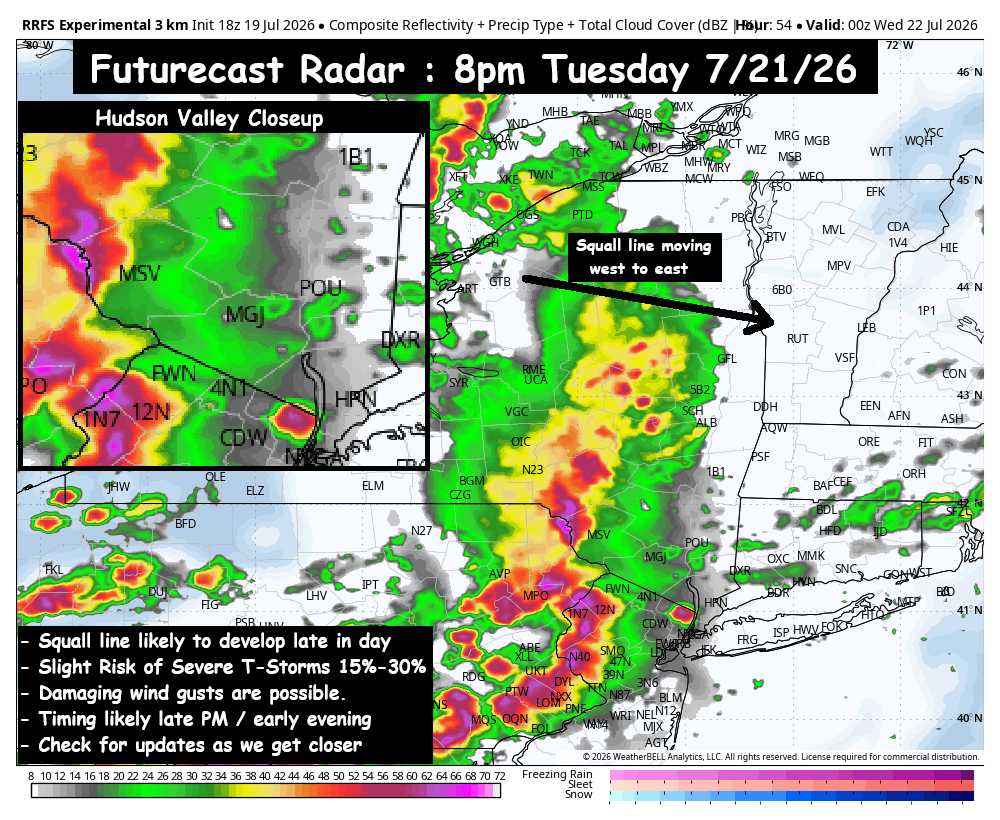
The clash of these two air masses has the potential to kick off severe T-Storms. The region remains in a “Slight Risk” with roughly a 15% to 30% chance of a severe storm in our area… but just to our SW is an “Enhanced Risk” of 30% to 45% chance of a severe storm. The line could develop between 5pm and 7pm, and push SE around sunset. One thing that could work in our favor, is the extended scattered showers & downpours during the day may stabilize the airmass over our area… and could help to reduce the severe threat. This is something we’ll watch closely, and update as things develop.
 
Another busy day shaping up on Tuesday. Be sure to pack the umbrella, and plan for unsettled weather. Have a great start to your day!

Eyes on the Next Weather Maker: Tuesday PM

– Humid, w/ Scattered Showers & T-Storms Tuesday PM
– Potential Severe weather event Tuesday Late afternoon / evening
– Slight Risk (15% to 30%) of severe T-storm in Hudson Valley area
An absolutely gorgeous Sunday across the Hudson Valley. Low humidity, no smoke… lots of sunshine, and afternoon highs in the upper 70s. Now we look forward to the week ahead, and we have another upper-level trough digging in for Tuesday, and that appears poised to touch off scattered showers and T-Storms around the Hudson Valley and northeast. We’ll see a southerly flow out ahead of it Monday night into Tuesday. The front has cool & dry air behind it, and that should be enough to touch off a squall line of strong to severe storms late on Tuesday.
The details will become more clear as we get closer to the event. The timing looks like 4pm to 10pm on Tuesday, and at the moment we have a ‘Slight Risk’ (15% to 30% chance) of a severe T-Storm in the Hudson Valley. The primary risk would be for damaging wind gusts, but with this event over 48 hours away, updates will be very important to focusing in on the details with this event. For perspective on the intensity of this severe weather threat… at the moment, this severe threat does not look as intense as the Saturday severe T-Storm event we just experienced.
 
We’ll have to watch this closely over the next 48 hours to see if the severe threat rises. We’ll have updates as we get closer. For now, enjoy the beautiful weather.

Saturday Outlook : Strong to Severe T-Storm Potential 

Smoke has dominated the headlines this week, thanks to large Canadian wildfires sending thick smoke hundreds of miles away to our neck of the woods. But our eyes turn to a new threat for Saturday… as we have showers and T-Storms poised to move into the Hudson Valley.
 
Summary:
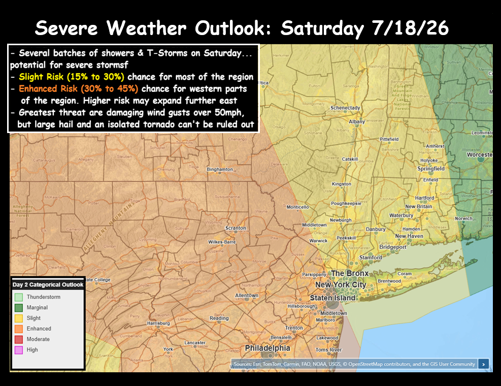
– Slight to Enhanced Risk (15%-45%) of Severe T-Storms in our area
– Severe threat highest between 6pm and 10pm
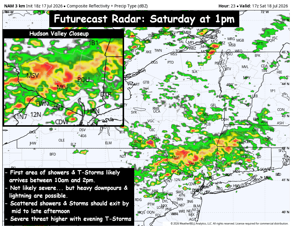
– First wave of showers & T-Storms 10am to 2pm
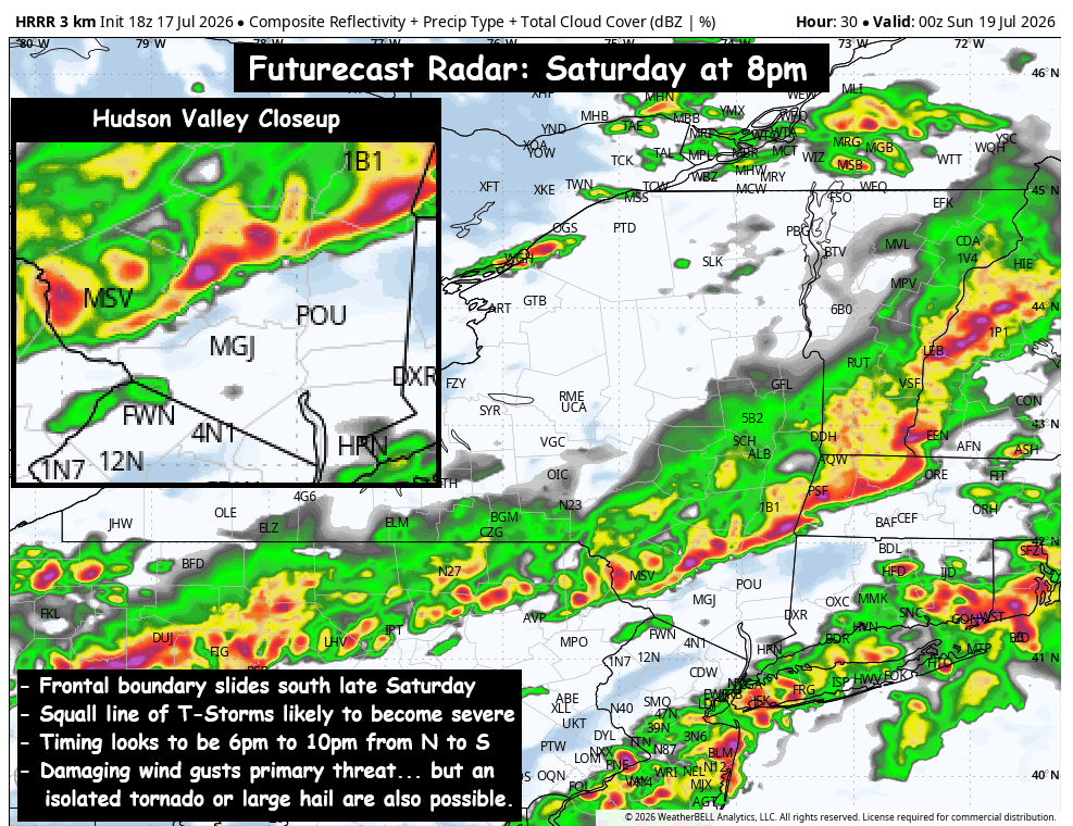
– Squall line of severe T-Storms arrives 6pm to 10pm
– Damaging wind gusts biggest threat, isolated tornado & hail possible
Low pressure in southern Canada will swing a cold front through NY state later on Saturday. The trough digging in will likely touch off areas of showers and T-Storms during the late morning into early afternoon hours. The longer the first wave of rain showers and clouds persist… the more stabilized the atmosphere should be later in the day on Saturday, which would lower the severe threat. Something we’ll be watching closely during the day.
The squall line associated with the cold front looks like it could pack a punch. The highest threat appears to be further north and west of our area, but the Hudson Valley is on the border of Slight (15% to 30%) and Enhanced Risk (30% to 45%). Those ranges represent the likelihood of a severe T-Storm in the Hudson Valley. The squall line appears likely to reach the Catskills & Upper Hudson Valley between 6pm and 8pm… and push southward during the evening. Strong wind gusts, frequent lightning, and heavy downpours are likely… and those gusts could exceed 50mph and be severe (30% to 45% chance). We can’t completely rule out an isolated tornado (roughly 5% chance). Conditions should gradually improve, with showers & storms tapering off around midnight.
 
We’ll be monitoring this very closely over the next 24 hours, so be sure to check back for updates Saturday morning…

Wednesday PM Canadian Wildfire Smoke Update

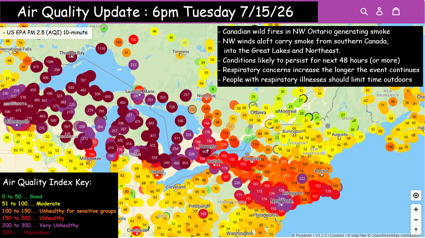
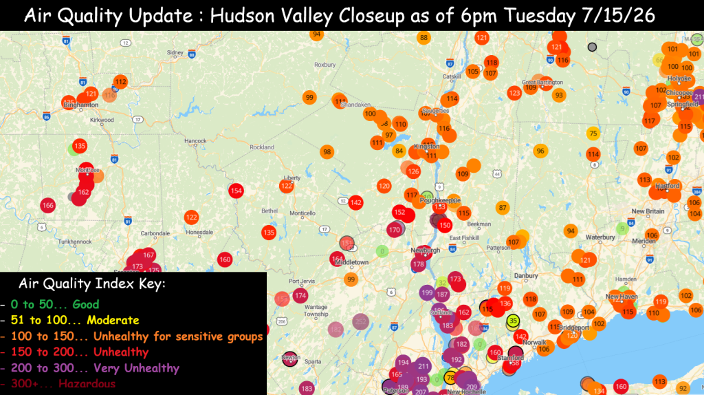
The impact of the Canadian wildfires continues to be felt across the Hudson Valley, and likely will be with us for the next 1 to 2 days at least. These images are from the ‘Purple Air’ website showing the air quality over the past hour. On a normal day, the air quality typically fluctuates from between 0 – 50 (good) to 51 – 100 (moderate). You can see the large area from the Great Lakes down through NY state and New England, all in the orange, red and purple categories… indicating an Air Quality Index of 101 to 300+. This is typically unhealthy air and potentially hazardous to not just people with pre-existing respiratory illnesses, but to the general public… especially the longer you’re exposed to the air.
Some of the readings in the Great Lakes are approaching 1000, and the recommendation in those areas is to stay indoors. We don’t expect the air quality to get to those levels here in the Hudson Valley… but we could see readings approaching and possibly exceeding the “Hazardous” levels here locally. So it’s a good idea to keep an eye on the readings in your area. You should be able to get a decent idea of the air quality using your vision… as the thicker the smoke, the darker and hazier the sky will become. Last June we had wildfire smoke so severe, it turned the skies a brownish-orange color for many parts of the region. We saw a hint of that on Wednesday, and we’ll have to see how dense the smoke is on Thursday… but similar conditions are possible.
 
We’ll provide updates along the way… but if you’re sensitive to the air quality, please be careful and alert to the conditions over the next day or two.
Air Quality Map: https://map.purpleair.com/

HVW Work Week Outlook – The Heat Returns

We move into the peak of meteorological summer, and this week it will certainly feel like it. A strong upper level ridge will settle over the middle of North America, and allow heat to overtake the pattern once again. It will also keep the eastern half of the US dry, under a dome of high pressure.
 
– Monday… Sunshine and blue skies will mix with some fair weather clouds. Humidity looks to be on the low/moderate side. So “real feel” temps should be close to the air temperature. High in the mid 80s.
– Monday Night… Partly cloudy and mild. Lows in the mid 60s.
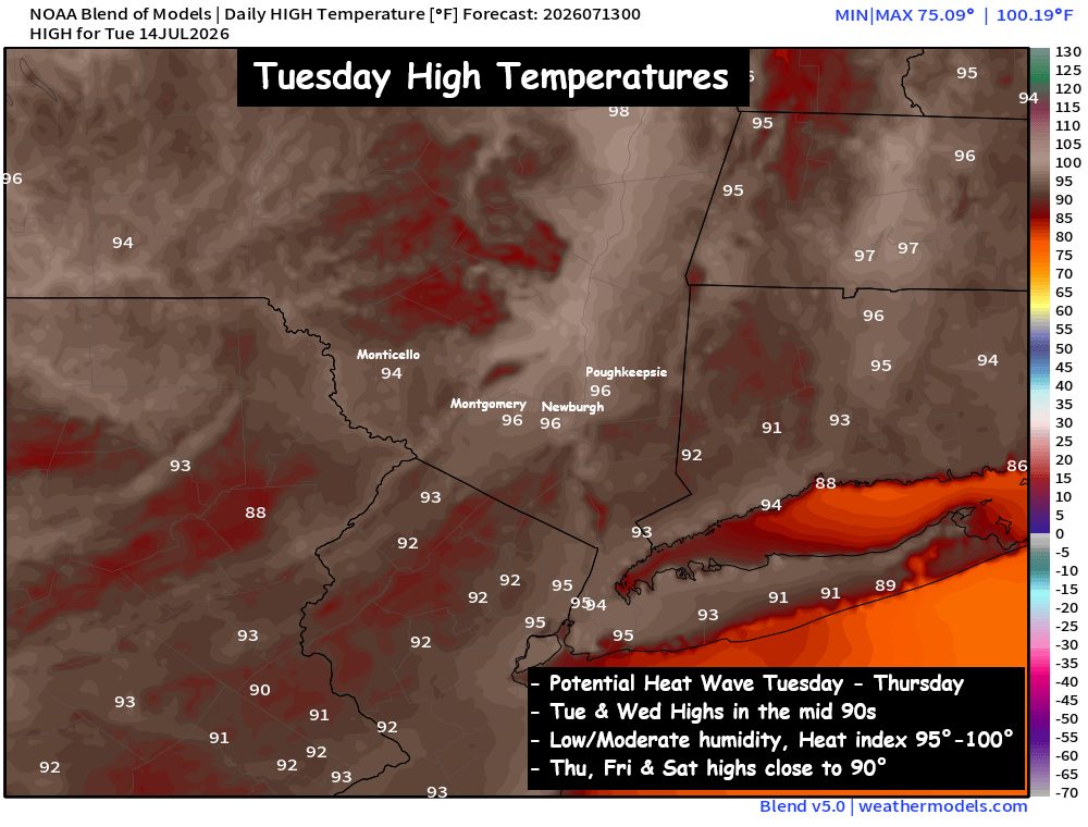
– Tuesday… Mostly sunny and hot… not too humid! High in the mid 90s. Low to moderate humidity, should keep heat index values 95° to 100°.
– Wednesday… Mix of clouds and sun… hot but with low humidity. High in the mid 90s. Heat index in the mid 90s.
– Thursday… Sunshine mixing with clouds… not as hot. High around 90°. Low humidity… making for heat index in the upper 80s to near 90°.
 
Poughkeepsie Record Highs:
Tuesday : 99° ; Wednesday : 98°
 
Tuesday and Wednesday look impressively hot. Highs both days should climb well into the 90s. We do have a shot at record highs this week, but we’ll likely be a degree or two short each day. But this heat wave won’t be nearly as humid as the one two weeks ago. A weak NW flow should develop mid-week, and it should push drier air (less humid) into the Hudson Valley by Wednesday and Thursday. It may not provide much relief from the heat… but it should help us avoid oppressive heat index values this week. Tuesday is likely to be the most uncomfortable, before less humid air arrives on Wednesday… and by Thursday the air mass looks a few degrees cooler.
 
Prepare for another hot week across the Hudson Valley. At least the humidity won’t be oppressive like the last heat wave. We’ll share updates as we go. Stay cool!

Weekend Outlook : Beautiful Weather Returns

Over the last 2 weeks we’ve had record heat, soaking rains and flash flooding. This weekend is looking mainly dry… with temperatures very close to average for this time of year… for most locations, it should be a stellar weather weekend.
 
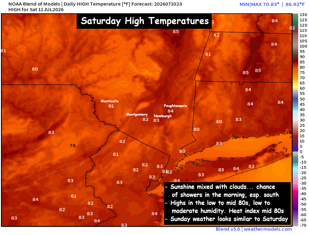
Saturday … Clouds are likely to start the morning, especially for the lower half of the valley. A small area of showers and embedded downpours are possible near sunrise (mostly south of I-84), but they should diminish before noon. The afternoon should see a mix of clouds and sun, with highs 80° to 85°. An isolated shower can’t be ruled out here or there.
 
Saturday Night… Mostly clear skies and mild. Low in the low to mid 60s.
 
Sunday… Sunshine mixing with clouds, seasonable temperatures and mainly dry. High in the low to mid 80s. Humidity levels low/moderate and real feel temps in the mid 80s.
 
A LOOK AHEAD…
Next week we’re looking at the potential for another brief heatwave, as a ridge of high pressure builds again over the eastern half of the US. The ridge will not be long lasting, but it will be strong enough to get highs near or above 90° on Tuesday, Wednesday and Thursday. This heat wave looks NOTHING like what we saw at the start of the month, but it could be hot enough to impact your outdoor plans.
 
But the heat wave likely breaks on Thursday or Friday, when a frontal boundary slides south from Canada. That should bring us cooler temps NEXT weekend, with afternoon highs around 80° and overnight lows in the 50s.
 
We’ll track the potential for AM showers on Saturday, the best chance appears south of I-84. But otherwise, the weekend weather looks excellent for outdoor activities! Have a great start to your weekend!

Rainfall Summary : Sunday 7/5 to Tuesday 7/7

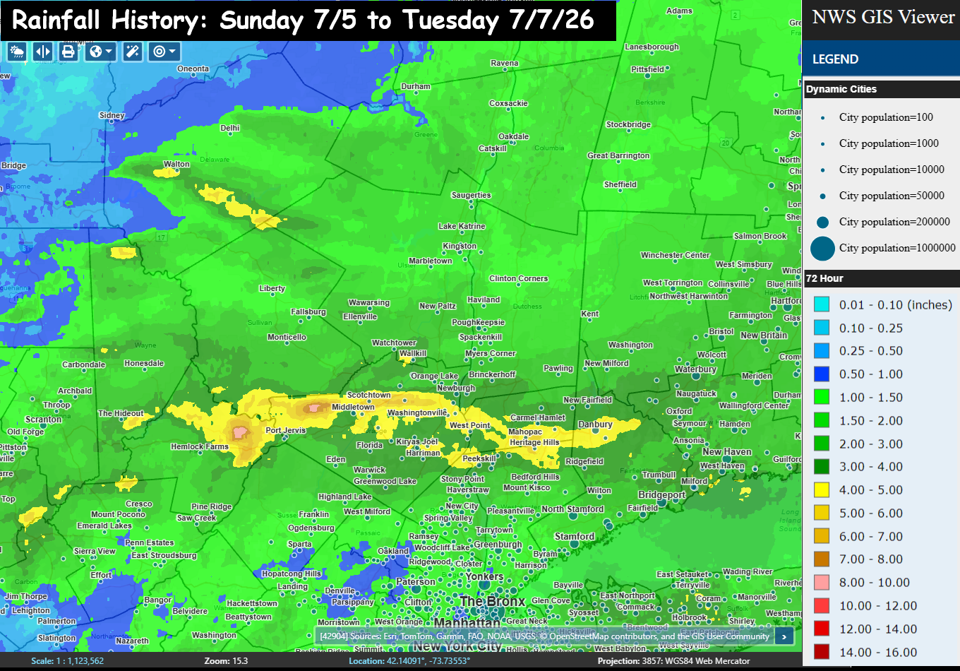
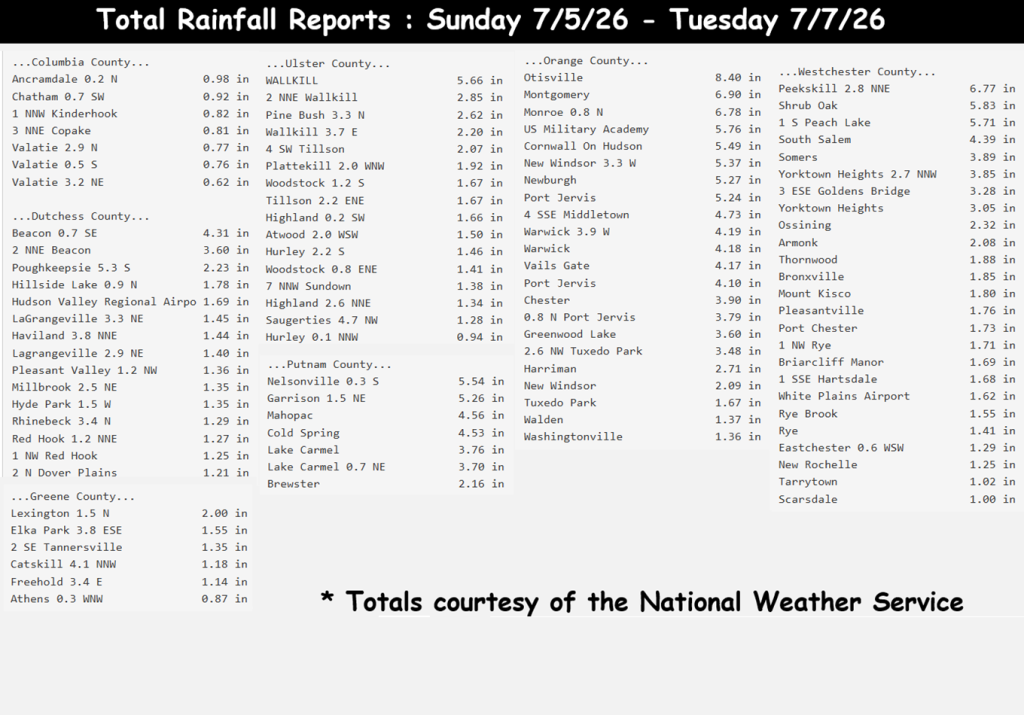
Much needed rainfall over the last couple days, as the entire region saw roughly 1 to 3 inches of rain. But we had stressed the concern that there would be pockets of substantially higher rainfall, but were not sure exactly where that would be. Congratulations to the I-84 corridor, as the band of yellow (which represents 4 to 5 inches of rain) follows I-84 almost perfectly from PA to CT. Within that area… pockets of 5 to 8 inches of rainfall and areas of Flash Flooding were found. Some of the big “winners” in rainfall totals….
– Otisville 8.40″ ; – Montgomery 6.90″ ; – Monroe 6.78″ ;
– Peekskill 6.77″ ; – West Point 5.76″ ; – Wallkill 5.66″
Some areas got more than they needed… but in general, a long term, multi-day rain event should go a long way toward helping the drought situation. We’ll wait to see if a dent was made. Thank you all for your continued support and trust of HVW.

HVW 12 hour Rainfall Summary : Sun 12pm – Mon 12am

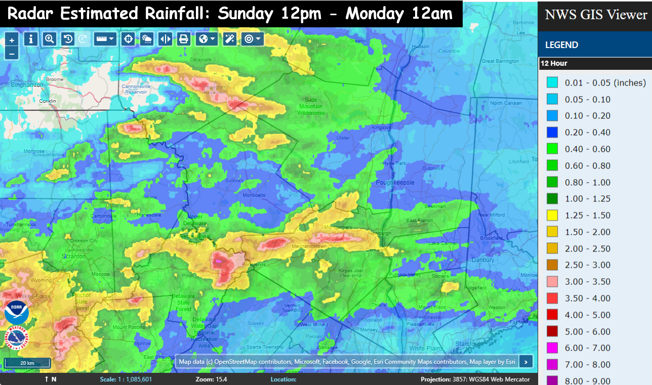
This map may be hard to read… but it tells you what you need to know about the next 24 to 36 hours. This map shows the radar estimated rainfall totals from 12pm Sunday through midnight… a 12 hour period. The key is on the right side of the graphic. It shows the entire region has seen at least a tenth of an inch of rain. The areas in green are locations that have seen half an inch in the last 12 hours. Where you see yellow… it’s roughly 1 to 2 inches. The orange is where they’ve seen 2 to 3 inches already… and the pink and red is where anywhere from 3 to 5 inches of rain has fallen… ALREADY.
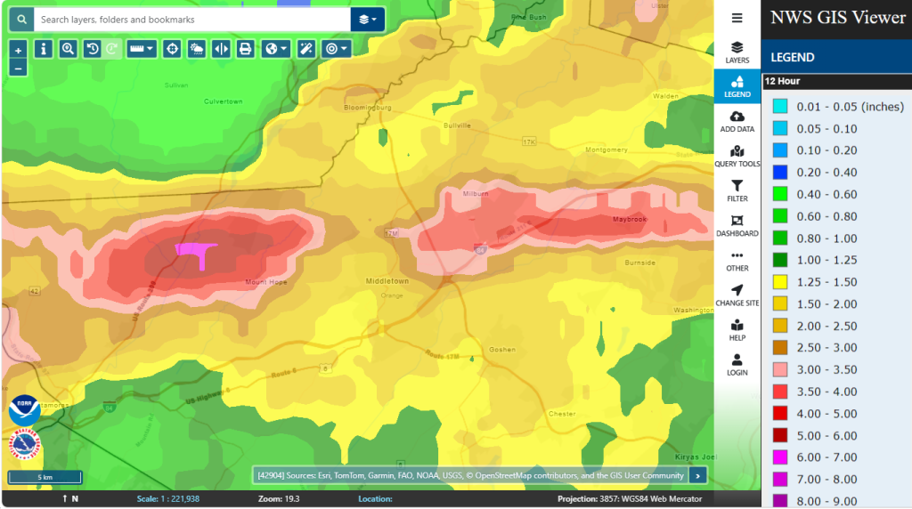
Notice how the torrential rainfall areas are very narrow… and hit or miss. You’ve got an area in the Catskills that we talked about this afternoon. Then there are 2 pockets in Orange county. One pocket of 3 to 5 inches of rain that has fallen near Mount Hope and Otisville… then another pocket east from roughly the Galleria at Crystal Run… east to Maybrook.
 
This will mean we’ll have pockets of much higher rainfall totals than surrounding areas. So be on guard for flash flooding potential. We will share the alerts as quickly as we can. Stay dry friends…